You are here: Home > Network List > IU - Global Seismograph Network (GSN - IRIS/USGS) Stations List
> Station XMAS Kiritimati Island, Republic of Kiribati > Earthquake Result Viewer
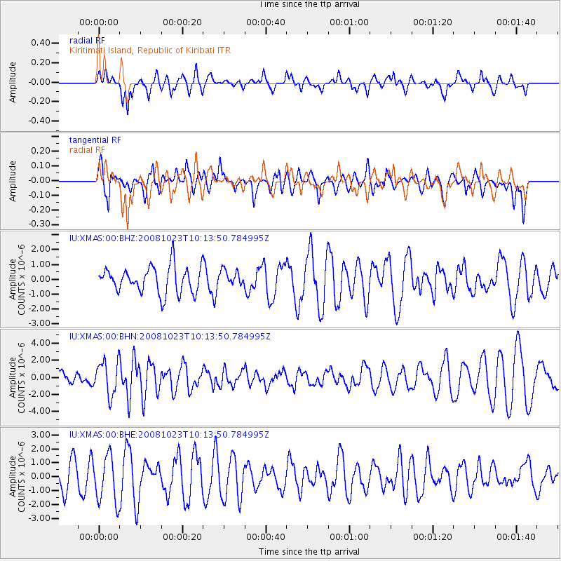
XMAS Kiritimati Island, Republic of Kiribati - Earthquake Result Viewer
*The percent match for this event was below the threshold and hence no stack was calculated.
| Earthquake location: |
Admiralty Islands Region, P.N.G. |
| Earthquake latitude/longitude: |
-2.6/145.6 |
| Earthquake time(UTC): |
2008/10/23 (297) 10:04:35 GMT |
| Earthquake Depth: |
10 km |
| Earthquake Magnitude: |
6.0 MB, 6.3 MS, 6.3 MW, 6.3 MW |
| Earthquake Catalog/Contributor: |
WHDF/NEIC |
|
| Network: |
IU Global Seismograph Network (GSN - IRIS/USGS) |
| Station: |
XMAS Kiritimati Island, Republic of Kiribati |
| Lat/Lon: |
2.04 N/157.45 W |
| Elevation: |
2.0 m |
|
| Distance: |
57.2 deg |
| Az: |
85.886 deg |
| Baz: |
265.567 deg |
| Ray Param: |
$rayparam |
*The percent match for this event was below the threshold and hence was not used in the summary stack. |
|
| Radial Match: |
55.18188 % |
| Radial Bump: |
400 |
| Transverse Match: |
57.115166 % |
| Transverse Bump: |
400 |
| SOD ConfigId: |
2560 |
| Insert Time: |
2010-03-02 15:49:40.678 +0000 |
| GWidth: |
2.5 |
| Max Bumps: |
400 |
| Tol: |
0.001 |
|
Signal To Noise
| Channel | StoN | STA | LTA |
| IU:XMAS:00:BHN:20081023T10:13:50.784995Z | 2.2498248 | 2.0255873E-6 | 9.003311E-7 |
| IU:XMAS:00:BHE:20081023T10:13:50.784995Z | 1.5409101 | 1.733169E-6 | 1.1247697E-6 |
| IU:XMAS:00:BHZ:20081023T10:13:50.784995Z | 0.5855509 | 5.2014394E-7 | 8.8829836E-7 |
| Arrivals |
| Ps | |
| PpPs | |
| PsPs/PpSs | |


