You are here: Home > Network List > PM - Portuguese National Seismic Network Stations List
> Station PFVI PM.PFVI > Earthquake Result Viewer
PFVI PM.PFVI - Earthquake Result Viewer
| Earthquake location: |
Alaska Peninsula |
| Earthquake latitude/longitude: |
56.7/-156.5 |
| Earthquake time(UTC): |
2015/05/29 (149) 07:00:08 GMT |
| Earthquake Depth: |
62 km |
| Earthquake Magnitude: |
6.8 MWP, 6.8 MI |
| Earthquake Catalog/Contributor: |
NEIC PDE/NEIC COMCAT |
|
| Network: |
PM Portuguese National Seismic Network |
| Station: |
PFVI PM.PFVI |
| Lat/Lon: |
37.13 N/8.83 W |
| Elevation: |
189 m |
|
| Distance: |
82.6 deg |
| Az: |
25.505 deg |
| Baz: |
342.708 deg |
| Ray Param: |
0.04665249 |
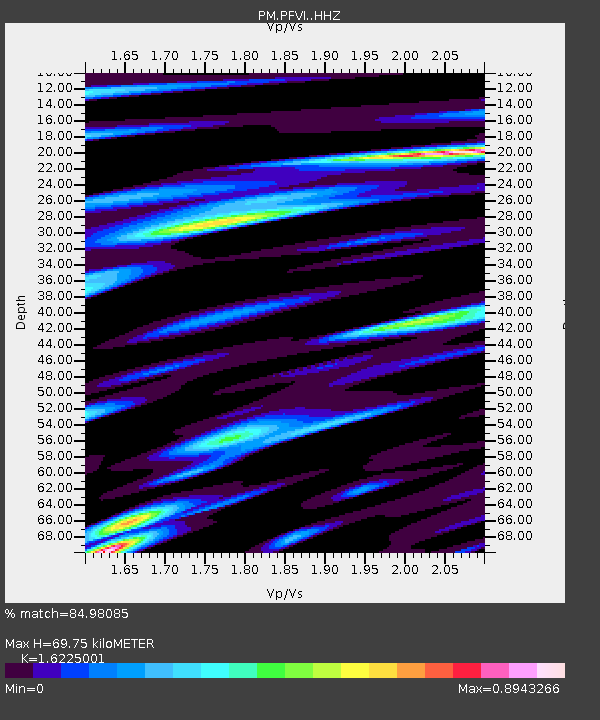
| Estimated Moho Depth: |
69.75 km |
| Estimated Crust Vp/Vs: |
1.62 |
| Assumed Crust Vp: |
6.048 km/s |
| Estimated Crust Vs: |
3.728 km/s |
| Estimated Crust Poisson's Ratio: |
0.19 |
|
| Radial Match: |
84.98085 % |
| Radial Bump: |
400 |
| Transverse Match: |
78.27906 % |
| Transverse Bump: |
400 |
| SOD ConfigId: |
7422571 |
| Insert Time: |
2019-04-19 02:42:05.812 +0000 |
| GWidth: |
2.5 |
| Max Bumps: |
400 |
| Tol: |
0.001 |
|

Signal To Noise
| Channel | StoN | STA | LTA |
| PM:PFVI: :HHZ:20150529T07:11:53.179978Z | 5.980653 | 4.223786E-6 | 7.062417E-7 |
| PM:PFVI: :HHN:20150529T07:11:53.179978Z | 3.488497 | 1.1380004E-6 | 3.262151E-7 |
| PM:PFVI: :HHE:20150529T07:11:53.179978Z | 0.912074 | 5.3349584E-7 | 5.84926E-7 |
| Arrivals |
| Ps | 7.4 SECOND |
| PpPs | 29 SECOND |
| PsPs/PpSs | 37 SECOND |


