You are here: Home > Network List > PO - Portable Observatories for Lithospheric Analysis and Research Investigating Seis Stations List
> Station CHGQ Chibougamau, QC > Earthquake Result Viewer
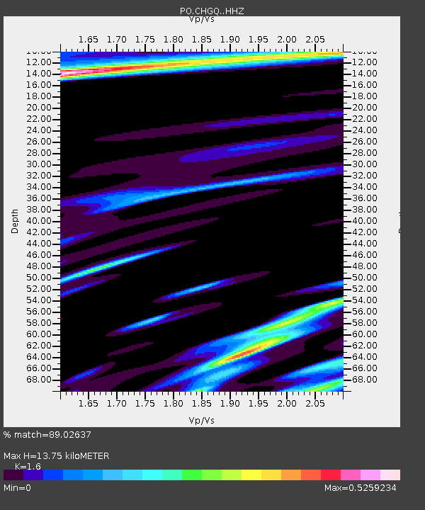
CHGQ Chibougamau, QC - Earthquake Result Viewer
| Earthquake location: |
Alaska Peninsula |
| Earthquake latitude/longitude: |
56.7/-156.5 |
| Earthquake time(UTC): |
2015/05/29 (149) 07:00:08 GMT |
| Earthquake Depth: |
62 km |
| Earthquake Magnitude: |
6.8 MWP, 6.8 MI |
| Earthquake Catalog/Contributor: |
NEIC PDE/NEIC COMCAT |
|
| Network: |
PO Portable Observatories for Lithospheric Analysis and Research Investigating Seis |
| Station: |
CHGQ Chibougamau, QC |
| Lat/Lon: |
49.91 N/74.37 W |
| Elevation: |
406 m |
|
| Distance: |
46.8 deg |
| Az: |
61.532 deg |
| Baz: |
311.397 deg |
| Ray Param: |
0.07025257 |
| Estimated Moho Depth: |
13.75 km |
| Estimated Crust Vp/Vs: |
1.60 |
| Assumed Crust Vp: |
6.61 km/s |
| Estimated Crust Vs: |
4.131 km/s |
| Estimated Crust Poisson's Ratio: |
0.18 |
|
| Radial Match: |
89.02637 % |
| Radial Bump: |
400 |
| Transverse Match: |
63.861473 % |
| Transverse Bump: |
400 |
| SOD ConfigId: |
7422571 |
| Insert Time: |
2019-04-19 02:42:09.286 +0000 |
| GWidth: |
2.5 |
| Max Bumps: |
400 |
| Tol: |
0.001 |
|

Signal To Noise
| Channel | StoN | STA | LTA |
| PO:CHGQ: :HHZ:20150529T07:08:00.90001Z | 23.109982 | 3.0743718E-6 | 1.330322E-7 |
| PO:CHGQ: :HHN:20150529T07:08:00.90001Z | 7.869338 | 1.49115E-6 | 1.8948863E-7 |
| PO:CHGQ: :HHE:20150529T07:08:00.90001Z | 3.4463637 | 1.1039804E-6 | 3.2033194E-7 |
| Arrivals |
| Ps | 1.3 SECOND |
| PpPs | 5.0 SECOND |
| PsPs/PpSs | 6.4 SECOND |


