You are here: Home > Network List > PO - Portable Observatories for Lithospheric Analysis and Research Investigating Seis Stations List
> Station LATQ La Tuque, Quebec, QC > Earthquake Result Viewer
LATQ La Tuque, Quebec, QC - Earthquake Result Viewer
| Earthquake location: |
Alaska Peninsula |
| Earthquake latitude/longitude: |
56.7/-156.5 |
| Earthquake time(UTC): |
2015/05/29 (149) 07:00:08 GMT |
| Earthquake Depth: |
62 km |
| Earthquake Magnitude: |
6.8 MWP, 6.8 MI |
| Earthquake Catalog/Contributor: |
NEIC PDE/NEIC COMCAT |
|
| Network: |
PO Portable Observatories for Lithospheric Analysis and Research Investigating Seis |
| Station: |
LATQ La Tuque, Quebec, QC |
| Lat/Lon: |
47.38 N/72.78 W |
| Elevation: |
163 m |
|
| Distance: |
49.3 deg |
| Az: |
63.079 deg |
| Baz: |
313.625 deg |
| Ray Param: |
0.068646535 |
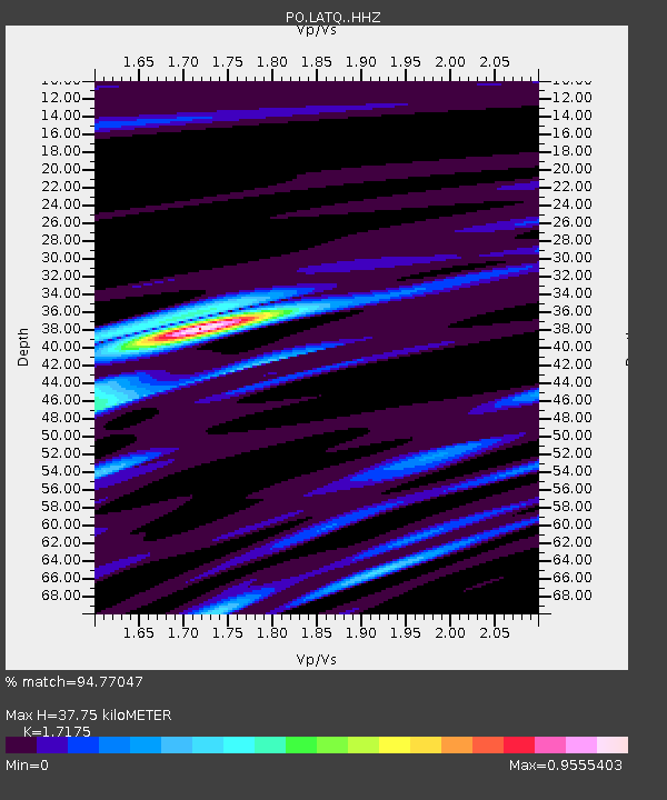
| Estimated Moho Depth: |
37.75 km |
| Estimated Crust Vp/Vs: |
1.72 |
| Assumed Crust Vp: |
6.61 km/s |
| Estimated Crust Vs: |
3.849 km/s |
| Estimated Crust Poisson's Ratio: |
0.24 |
|
| Radial Match: |
94.77047 % |
| Radial Bump: |
309 |
| Transverse Match: |
86.97172 % |
| Transverse Bump: |
400 |
| SOD ConfigId: |
7422571 |
| Insert Time: |
2019-04-19 02:42:12.233 +0000 |
| GWidth: |
2.5 |
| Max Bumps: |
400 |
| Tol: |
0.001 |
|

Signal To Noise
| Channel | StoN | STA | LTA |
| PO:LATQ: :HHZ:20150529T07:08:20.060013Z | 32.670452 | 2.980483E-6 | 9.12287E-8 |
| PO:LATQ: :HHN:20150529T07:08:20.060013Z | 11.555487 | 9.963261E-7 | 8.622104E-8 |
| PO:LATQ: :HHE:20150529T07:08:20.060013Z | 13.45984 | 1.252977E-6 | 9.309004E-8 |
| Arrivals |
| Ps | 4.4 SECOND |
| PpPs | 15 SECOND |
| PsPs/PpSs | 19 SECOND |


