You are here: Home > Network List > IU - Global Seismograph Network (GSN - IRIS/USGS) Stations List
> Station XMAS Kiritimati Island, Republic of Kiribati > Earthquake Result Viewer
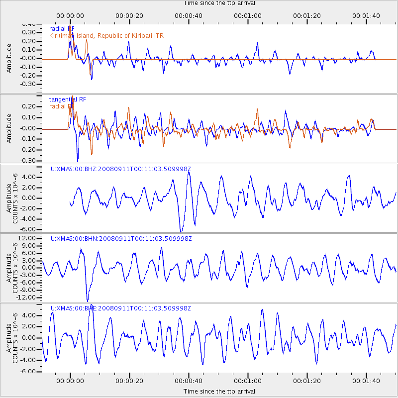
XMAS Kiritimati Island, Republic of Kiribati - Earthquake Result Viewer
*The percent match for this event was below the threshold and hence no stack was calculated.
| Earthquake location: |
Halmahera, Indonesia |
| Earthquake latitude/longitude: |
1.9/127.4 |
| Earthquake time(UTC): |
2008/09/11 (255) 00:00:02 GMT |
| Earthquake Depth: |
96 km |
| Earthquake Magnitude: |
6.2 MB, 6.6 MW, 6.6 MW |
| Earthquake Catalog/Contributor: |
WHDF/NEIC |
|
| Network: |
IU Global Seismograph Network (GSN - IRIS/USGS) |
| Station: |
XMAS Kiritimati Island, Republic of Kiribati |
| Lat/Lon: |
2.04 N/157.45 W |
| Elevation: |
2.0 m |
|
| Distance: |
75.1 deg |
| Az: |
88.395 deg |
| Baz: |
271.399 deg |
| Ray Param: |
$rayparam |
*The percent match for this event was below the threshold and hence was not used in the summary stack. |
|
| Radial Match: |
72.867546 % |
| Radial Bump: |
400 |
| Transverse Match: |
59.80373 % |
| Transverse Bump: |
400 |
| SOD ConfigId: |
2504 |
| Insert Time: |
2010-03-02 15:49:49.623 +0000 |
| GWidth: |
2.5 |
| Max Bumps: |
400 |
| Tol: |
0.001 |
|
Signal To Noise
| Channel | StoN | STA | LTA |
| IU:XMAS:00:BHN:20080911T00:11:03.509998Z | 2.1242251 | 3.8043463E-6 | 1.7909337E-6 |
| IU:XMAS:00:BHE:20080911T00:11:03.509998Z | 0.56164896 | 1.16594E-6 | 2.075923E-6 |
| IU:XMAS:00:BHZ:20080911T00:11:03.509998Z | 1.2362162 | 1.5097864E-6 | 1.2212963E-6 |
| Arrivals |
| Ps | |
| PpPs | |
| PsPs/PpSs | |


