You are here: Home > Network List > PR - Puerto Rico Seismic Network (PRSN) & Puerto Rico Strong Motion Program (PRSMP) Stations List
> Station MTP Vieques, Puerto Rico(T3265) > Earthquake Result Viewer
MTP Vieques, Puerto Rico(T3265) - Earthquake Result Viewer
| Earthquake location: |
Alaska Peninsula |
| Earthquake latitude/longitude: |
56.7/-156.5 |
| Earthquake time(UTC): |
2015/05/29 (149) 07:00:08 GMT |
| Earthquake Depth: |
62 km |
| Earthquake Magnitude: |
6.8 MWP, 6.8 MI |
| Earthquake Catalog/Contributor: |
NEIC PDE/NEIC COMCAT |
|
| Network: |
PR Puerto Rico Seismic Network (PRSN) & Puerto Rico Strong Motion Program (PRSMP) |
| Station: |
MTP Vieques, Puerto Rico(T3265) |
| Lat/Lon: |
18.10 N/65.55 W |
| Elevation: |
35 m |
|
| Distance: |
75.6 deg |
| Az: |
79.057 deg |
| Baz: |
325.286 deg |
| Ray Param: |
0.051427793 |
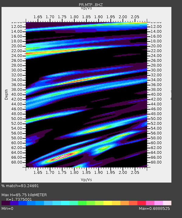
| Estimated Moho Depth: |
65.75 km |
| Estimated Crust Vp/Vs: |
1.74 |
| Assumed Crust Vp: |
5.14 km/s |
| Estimated Crust Vs: |
2.958 km/s |
| Estimated Crust Poisson's Ratio: |
0.25 |
|
| Radial Match: |
93.24691 % |
| Radial Bump: |
400 |
| Transverse Match: |
83.227974 % |
| Transverse Bump: |
400 |
| SOD ConfigId: |
7422571 |
| Insert Time: |
2019-04-19 02:42:23.709 +0000 |
| GWidth: |
2.5 |
| Max Bumps: |
400 |
| Tol: |
0.001 |
|

Signal To Noise
| Channel | StoN | STA | LTA |
| PR:MTP: :BHZ:20150529T07:11:15.449998Z | 18.049908 | 2.3922378E-6 | 1.3253462E-7 |
| PR:MTP: :BHN:20150529T07:11:15.449998Z | 4.64262 | 7.619626E-7 | 1.6412342E-7 |
| PR:MTP: :BHE:20150529T07:11:15.449998Z | 1.8023809 | 5.7313446E-7 | 3.1798743E-7 |
| Arrivals |
| Ps | 9.6 SECOND |
| PpPs | 34 SECOND |
| PsPs/PpSs | 44 SECOND |


