You are here: Home > Network List > PS - Pacific21 Stations List
> Station PATS 6onpei, Micronesia > Earthquake Result Viewer
PATS 6onpei, Micronesia - Earthquake Result Viewer

| Earthquake location: |
Alaska Peninsula |
| Earthquake latitude/longitude: |
56.7/-156.5 |
| Earthquake time(UTC): |
2015/05/29 (149) 07:00:08 GMT |
| Earthquake Depth: |
62 km |
| Earthquake Magnitude: |
6.8 MWP, 6.8 MI |
| Earthquake Catalog/Contributor: |
NEIC PDE/NEIC COMCAT |
|
| Network: |
PS Pacific21 |
| Station: |
PATS 6onpei, Micronesia |
| Lat/Lon: |
6.84 N/158.32 E |
| Elevation: |
10 m |
|
| Distance: |
61.0 deg |
| Az: |
233.614 deg |
| Baz: |
26.568 deg |
| Ray Param: |
0.061014272 |
| Estimated Moho Depth: |
68.5 km |
| Estimated Crust Vp/Vs: |
1.68 |
| Assumed Crust Vp: |
4.24 km/s |
| Estimated Crust Vs: |
2.531 km/s |
| Estimated Crust Poisson's Ratio: |
0.22 |
|
| Radial Match: |
87.27719 % |
| Radial Bump: |
400 |
| Transverse Match: |
82.07855 % |
| Transverse Bump: |
400 |
| SOD ConfigId: |
7422571 |
| Insert Time: |
2019-04-19 02:42:28.529 +0000 |
| GWidth: |
2.5 |
| Max Bumps: |
400 |
| Tol: |
0.001 |
|
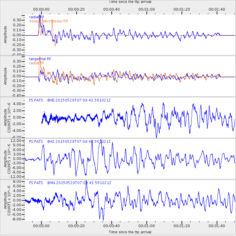
Signal To Noise
| Channel | StoN | STA | LTA |
| PS:PATS: :BHZ:20150529T07:09:43.561021Z | 9.0882015 | 4.5811566E-6 | 5.040774E-7 |
| PS:PATS: :BHN:20150529T07:09:43.561021Z | 1.4582608 | 1.4095904E-6 | 9.666244E-7 |
| PS:PATS: :BHE:20150529T07:09:43.561021Z | 1.9619812 | 1.2527324E-6 | 6.385038E-7 |
| Arrivals |
| Ps | 11 SECOND |
| PpPs | 42 SECOND |
| PsPs/PpSs | 53 SECOND |


