You are here: Home > Network List > RM - Regional Integrated Multi Hazard Early Warning System Stations List
> Station SLV Son La Vietnam > Earthquake Result Viewer
SLV Son La Vietnam - Earthquake Result Viewer
| Earthquake location: |
Alaska Peninsula |
| Earthquake latitude/longitude: |
56.7/-156.5 |
| Earthquake time(UTC): |
2015/05/29 (149) 07:00:08 GMT |
| Earthquake Depth: |
62 km |
| Earthquake Magnitude: |
6.8 MWP, 6.8 MI |
| Earthquake Catalog/Contributor: |
NEIC PDE/NEIC COMCAT |
|
| Network: |
RM Regional Integrated Multi Hazard Early Warning System |
| Station: |
SLV Son La Vietnam |
| Lat/Lon: |
21.33 N/103.91 E |
| Elevation: |
630 m |
|
| Distance: |
77.5 deg |
| Az: |
289.67 deg |
| Baz: |
33.861 deg |
| Ray Param: |
0.050142597 |
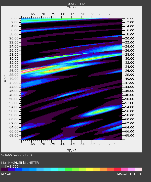
| Estimated Moho Depth: |
36.25 km |
| Estimated Crust Vp/Vs: |
1.61 |
| Assumed Crust Vp: |
6.35 km/s |
| Estimated Crust Vs: |
3.956 km/s |
| Estimated Crust Poisson's Ratio: |
0.18 |
|
| Radial Match: |
92.71904 % |
| Radial Bump: |
400 |
| Transverse Match: |
87.227715 % |
| Transverse Bump: |
400 |
| SOD ConfigId: |
7422571 |
| Insert Time: |
2019-04-19 02:42:39.748 +0000 |
| GWidth: |
2.5 |
| Max Bumps: |
400 |
| Tol: |
0.001 |
|

Signal To Noise
| Channel | StoN | STA | LTA |
| RM:SLV: :HHZ:20150529T07:11:25.317979Z | 80.19258 | 6.164503E-6 | 7.687123E-8 |
| RM:SLV: :HHN:20150529T07:11:25.317979Z | 42.159595 | 1.9400834E-6 | 4.60176E-8 |
| RM:SLV: :HHE:20150529T07:11:25.317979Z | 21.63845 | 1.004434E-6 | 4.6418947E-8 |
| Arrivals |
| Ps | 3.6 SECOND |
| PpPs | 14 SECOND |
| PsPs/PpSs | 18 SECOND |


