You are here: Home > Network List > IU - Global Seismograph Network (GSN - IRIS/USGS) Stations List
> Station XMAS Kiritimati Island, Republic of Kiribati > Earthquake Result Viewer
XMAS Kiritimati Island, Republic of Kiribati - Earthquake Result Viewer
*The percent match for this event was below the threshold and hence no stack was calculated.
| Earthquake location: |
Near N Coast Of New Guinea, P.N.G. |
| Earthquake latitude/longitude: |
-3.1/143.2 |
| Earthquake time(UTC): |
2009/08/10 (222) 17:46:23 GMT |
| Earthquake Depth: |
10 km |
| Earthquake Magnitude: |
5.9 MB, 5.6 MW, 5.6 MW |
| Earthquake Catalog/Contributor: |
WHDF/NEIC |
|
| Network: |
IU Global Seismograph Network (GSN - IRIS/USGS) |
| Station: |
XMAS Kiritimati Island, Republic of Kiribati |
| Lat/Lon: |
2.04 N/157.45 W |
| Elevation: |
20 m |
|
| Distance: |
59.6 deg |
| Az: |
85.808 deg |
| Baz: |
265.192 deg |
| Ray Param: |
$rayparam |
*The percent match for this event was below the threshold and hence was not used in the summary stack. |
|
| Radial Match: |
59.90428 % |
| Radial Bump: |
400 |
| Transverse Match: |
59.18683 % |
| Transverse Bump: |
400 |
| SOD ConfigId: |
2622 |
| Insert Time: |
2010-03-02 15:50:12.549 +0000 |
| GWidth: |
2.5 |
| Max Bumps: |
400 |
| Tol: |
0.001 |
|
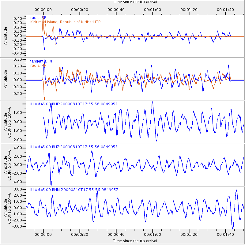
Signal To Noise
| Channel | StoN | STA | LTA |
| IU:XMAS:00:BHZ:20090810T17:55:56.084995Z | 1.8324414 | 1.9992533E-6 | 1.0910326E-6 |
| IU:XMAS:00:BHN:20090810T17:55:56.084995Z | 0.9352077 | 8.202956E-7 | 8.7712664E-7 |
| IU:XMAS:00:BHE:20090810T17:55:56.084995Z | 0.7404563 | 5.6594087E-7 | 7.6431365E-7 |
| Arrivals |
| Ps | |
| PpPs | |
| PsPs/PpSs | |


