You are here: Home > Network List > TA - USArray Transportable Network (new EarthScope stations) Stations List
> Station E55A Montcerf-Lytton, QC, CAN > Earthquake Result Viewer
E55A Montcerf-Lytton, QC, CAN - Earthquake Result Viewer
| Earthquake location: |
Alaska Peninsula |
| Earthquake latitude/longitude: |
56.7/-156.5 |
| Earthquake time(UTC): |
2015/05/29 (149) 07:00:08 GMT |
| Earthquake Depth: |
62 km |
| Earthquake Magnitude: |
6.8 MWP, 6.8 MI |
| Earthquake Catalog/Contributor: |
NEIC PDE/NEIC COMCAT |
|
| Network: |
TA USArray Transportable Network (new EarthScope stations) |
| Station: |
E55A Montcerf-Lytton, QC, CAN |
| Lat/Lon: |
46.45 N/76.06 W |
| Elevation: |
180 m |
|
| Distance: |
48.3 deg |
| Az: |
66.029 deg |
| Baz: |
313.185 deg |
| Ray Param: |
0.06929823 |
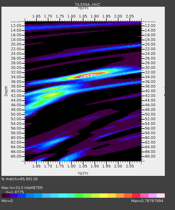
| Estimated Moho Depth: |
33.0 km |
| Estimated Crust Vp/Vs: |
1.88 |
| Assumed Crust Vp: |
6.622 km/s |
| Estimated Crust Vs: |
3.527 km/s |
| Estimated Crust Poisson's Ratio: |
0.30 |
|
| Radial Match: |
95.98138 % |
| Radial Bump: |
264 |
| Transverse Match: |
75.17793 % |
| Transverse Bump: |
400 |
| SOD ConfigId: |
7422571 |
| Insert Time: |
2019-04-19 02:43:16.239 +0000 |
| GWidth: |
2.5 |
| Max Bumps: |
400 |
| Tol: |
0.001 |
|
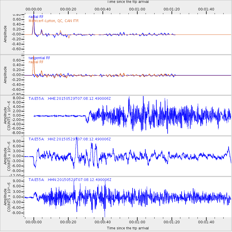
Signal To Noise
| Channel | StoN | STA | LTA |
| TA:E55A: :HHZ:20150529T07:08:12.490006Z | 31.739126 | 3.1933814E-6 | 1.006134E-7 |
| TA:E55A: :HHN:20150529T07:08:12.490006Z | 11.809911 | 1.3854584E-6 | 1.1731319E-7 |
| TA:E55A: :HHE:20150529T07:08:12.490006Z | 13.621375 | 1.5645411E-6 | 1.1485926E-7 |
| Arrivals |
| Ps | 4.6 SECOND |
| PpPs | 13 SECOND |
| PsPs/PpSs | 18 SECOND |


