You are here: Home > Network List > TA - USArray Transportable Network (new EarthScope stations) Stations List
> Station E60A Ste Agathe de Lotbiniere, QC, CAN > Earthquake Result Viewer
E60A Ste Agathe de Lotbiniere, QC, CAN - Earthquake Result Viewer
| Earthquake location: |
Alaska Peninsula |
| Earthquake latitude/longitude: |
56.7/-156.5 |
| Earthquake time(UTC): |
2015/05/29 (149) 07:00:08 GMT |
| Earthquake Depth: |
62 km |
| Earthquake Magnitude: |
6.8 MWP, 6.8 MI |
| Earthquake Catalog/Contributor: |
NEIC PDE/NEIC COMCAT |
|
| Network: |
TA USArray Transportable Network (new EarthScope stations) |
| Station: |
E60A Ste Agathe de Lotbiniere, QC, CAN |
| Lat/Lon: |
46.37 N/71.45 W |
| Elevation: |
181 m |
|
| Distance: |
50.6 deg |
| Az: |
63.197 deg |
| Baz: |
314.673 deg |
| Ray Param: |
0.067761265 |
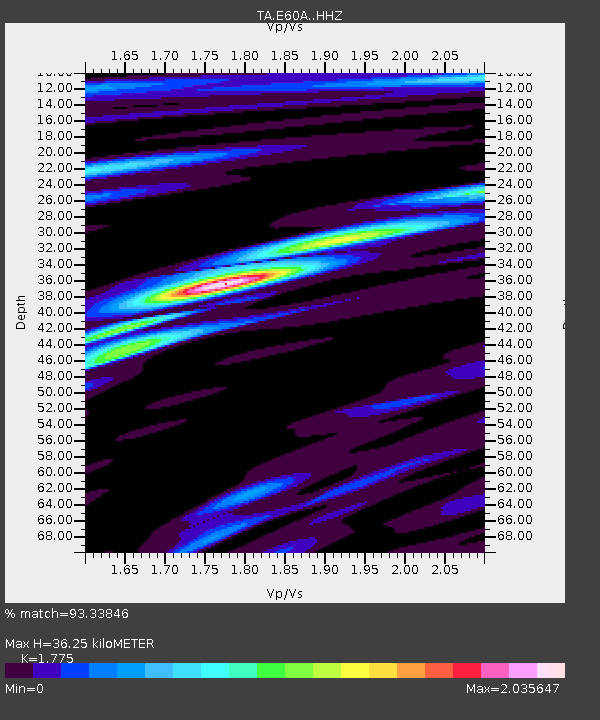
| Estimated Moho Depth: |
36.25 km |
| Estimated Crust Vp/Vs: |
1.77 |
| Assumed Crust Vp: |
6.61 km/s |
| Estimated Crust Vs: |
3.724 km/s |
| Estimated Crust Poisson's Ratio: |
0.27 |
|
| Radial Match: |
93.33846 % |
| Radial Bump: |
400 |
| Transverse Match: |
88.998795 % |
| Transverse Bump: |
400 |
| SOD ConfigId: |
7422571 |
| Insert Time: |
2019-04-19 02:43:20.024 +0000 |
| GWidth: |
2.5 |
| Max Bumps: |
400 |
| Tol: |
0.001 |
|
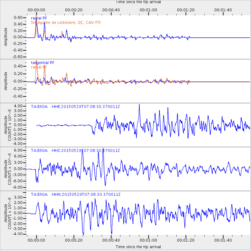
Signal To Noise
| Channel | StoN | STA | LTA |
| TA:E60A: :HHZ:20150529T07:08:30.370011Z | 32.678867 | 2.8647364E-6 | 8.7663274E-8 |
| TA:E60A: :HHN:20150529T07:08:30.370011Z | 16.078207 | 1.1601162E-6 | 7.215458E-8 |
| TA:E60A: :HHE:20150529T07:08:30.370011Z | 11.259923 | 9.2060657E-7 | 8.175958E-8 |
| Arrivals |
| Ps | 4.5 SECOND |
| PpPs | 14 SECOND |
| PsPs/PpSs | 19 SECOND |


