You are here: Home > Network List > TA - USArray Transportable Network (new EarthScope stations) Stations List
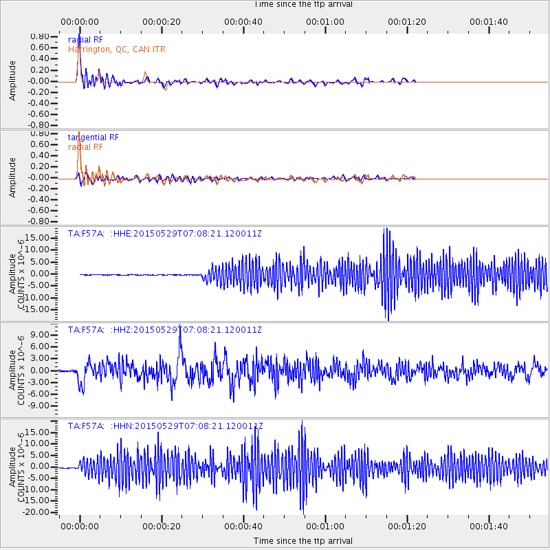
> Station F57A Harrington, QC, CAN > Earthquake Result Viewer
F57A Harrington, QC, CAN - Earthquake Result Viewer
| Earthquake location: |
Alaska Peninsula |
| Earthquake latitude/longitude: |
56.7/-156.5 |
| Earthquake time(UTC): |
2015/05/29 (149) 07:00:08 GMT |
| Earthquake Depth: |
62 km |
| Earthquake Magnitude: |
6.8 MWP, 6.8 MI |
| Earthquake Catalog/Contributor: |
NEIC PDE/NEIC COMCAT |
|
| Network: |
TA USArray Transportable Network (new EarthScope stations) |
| Station: |
F57A Harrington, QC, CAN |
| Lat/Lon: |
45.81 N/74.69 W |
| Elevation: |
178 m |
|
| Distance: |
49.4 deg |
| Az: |
65.778 deg |
| Baz: |
314.0 deg |
| Ray Param: |
0.068559565 |
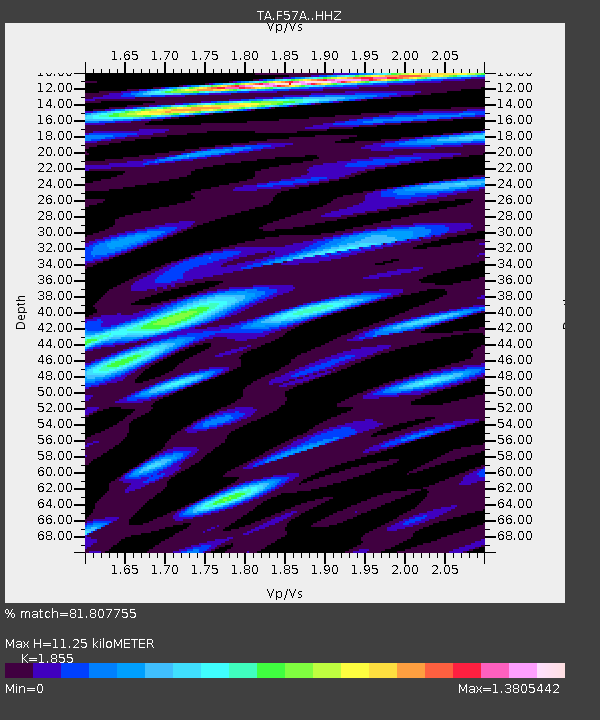
| Estimated Moho Depth: |
11.25 km |
| Estimated Crust Vp/Vs: |
1.86 |
| Assumed Crust Vp: |
6.419 km/s |
| Estimated Crust Vs: |
3.461 km/s |
| Estimated Crust Poisson's Ratio: |
0.30 |
|
| Radial Match: |
81.807755 % |
| Radial Bump: |
400 |
| Transverse Match: |
60.545147 % |
| Transverse Bump: |
400 |
| SOD ConfigId: |
7422571 |
| Insert Time: |
2019-04-19 02:43:22.654 +0000 |
| GWidth: |
2.5 |
| Max Bumps: |
400 |
| Tol: |
0.001 |
|
Signal To Noise
| Channel | StoN | STA | LTA |
| TA:F57A: :HHZ:20150529T07:08:21.120011Z | 22.7279 | 2.5983516E-6 | 1.14324315E-7 |
| TA:F57A: :HHN:20150529T07:08:21.120011Z | 28.268087 | 3.0033534E-6 | 1.0624537E-7 |
| TA:F57A: :HHE:20150529T07:08:21.120011Z | 25.99554 | 2.6644389E-6 | 1.02495996E-7 |
| Arrivals |
| Ps | 1.6 SECOND |
| PpPs | 4.7 SECOND |
| PsPs/PpSs | 6.3 SECOND |


