You are here: Home > Network List > TA - USArray Transportable Network (new EarthScope stations) Stations List
> Station F60A Warwick, QC, CAN > Earthquake Result Viewer
F60A Warwick, QC, CAN - Earthquake Result Viewer
| Earthquake location: |
Alaska Peninsula |
| Earthquake latitude/longitude: |
56.7/-156.5 |
| Earthquake time(UTC): |
2015/05/29 (149) 07:00:08 GMT |
| Earthquake Depth: |
62 km |
| Earthquake Magnitude: |
6.8 MWP, 6.8 MI |
| Earthquake Catalog/Contributor: |
NEIC PDE/NEIC COMCAT |
|
| Network: |
TA USArray Transportable Network (new EarthScope stations) |
| Station: |
F60A Warwick, QC, CAN |
| Lat/Lon: |
45.97 N/71.95 W |
| Elevation: |
229 m |
|
| Distance: |
50.7 deg |
| Az: |
63.884 deg |
| Baz: |
314.746 deg |
| Ray Param: |
0.06774115 |
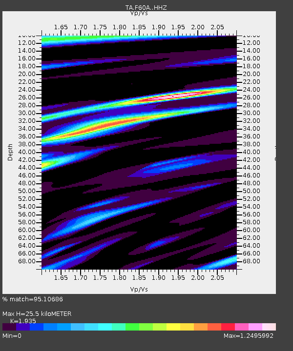
| Estimated Moho Depth: |
25.5 km |
| Estimated Crust Vp/Vs: |
1.93 |
| Assumed Crust Vp: |
6.419 km/s |
| Estimated Crust Vs: |
3.317 km/s |
| Estimated Crust Poisson's Ratio: |
0.32 |
|
| Radial Match: |
95.10686 % |
| Radial Bump: |
400 |
| Transverse Match: |
86.20099 % |
| Transverse Bump: |
400 |
| SOD ConfigId: |
7422571 |
| Insert Time: |
2019-04-19 02:43:25.907 +0000 |
| GWidth: |
2.5 |
| Max Bumps: |
400 |
| Tol: |
0.001 |
|
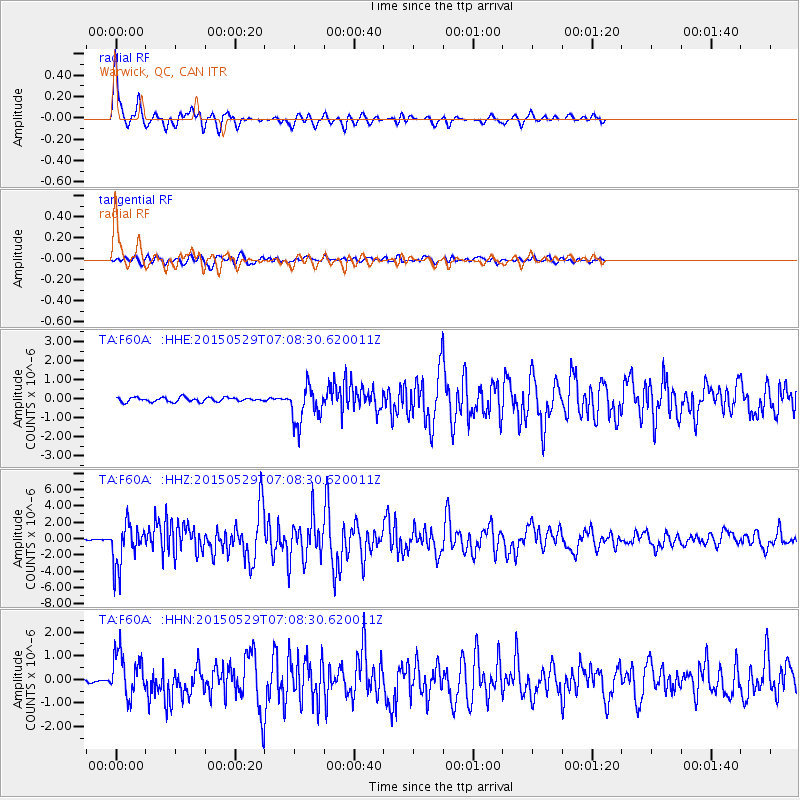
Signal To Noise
| Channel | StoN | STA | LTA |
| TA:F60A: :HHZ:20150529T07:08:30.620011Z | 20.618477 | 2.5583936E-6 | 1.2408258E-7 |
| TA:F60A: :HHN:20150529T07:08:30.620011Z | 10.9315195 | 9.3055945E-7 | 8.5126274E-8 |
| TA:F60A: :HHE:20150529T07:08:30.620011Z | 8.941472 | 9.773054E-7 | 1.0930029E-7 |
| Arrivals |
| Ps | 3.9 SECOND |
| PpPs | 11 SECOND |
| PsPs/PpSs | 15 SECOND |


