You are here: Home > Network List > TA - USArray Transportable Network (new EarthScope stations) Stations List
> Station G54A Lake Saint Peter, ON, CAN > Earthquake Result Viewer
G54A Lake Saint Peter, ON, CAN - Earthquake Result Viewer
| Earthquake location: |
Alaska Peninsula |
| Earthquake latitude/longitude: |
56.7/-156.5 |
| Earthquake time(UTC): |
2015/05/29 (149) 07:00:08 GMT |
| Earthquake Depth: |
62 km |
| Earthquake Magnitude: |
6.8 MWP, 6.8 MI |
| Earthquake Catalog/Contributor: |
NEIC PDE/NEIC COMCAT |
|
| Network: |
TA USArray Transportable Network (new EarthScope stations) |
| Station: |
G54A Lake Saint Peter, ON, CAN |
| Lat/Lon: |
45.40 N/78.09 W |
| Elevation: |
465 m |
|
| Distance: |
48.0 deg |
| Az: |
68.368 deg |
| Baz: |
313.292 deg |
| Ray Param: |
0.069496386 |
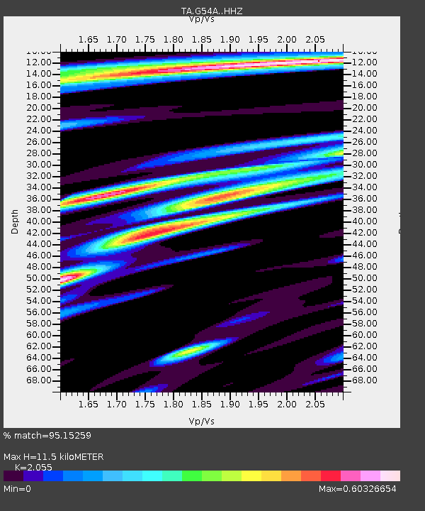
| Estimated Moho Depth: |
11.5 km |
| Estimated Crust Vp/Vs: |
2.06 |
| Assumed Crust Vp: |
6.577 km/s |
| Estimated Crust Vs: |
3.2 km/s |
| Estimated Crust Poisson's Ratio: |
0.34 |
|
| Radial Match: |
95.15259 % |
| Radial Bump: |
320 |
| Transverse Match: |
80.858055 % |
| Transverse Bump: |
400 |
| SOD ConfigId: |
7422571 |
| Insert Time: |
2019-04-19 02:43:28.096 +0000 |
| GWidth: |
2.5 |
| Max Bumps: |
400 |
| Tol: |
0.001 |
|

Signal To Noise
| Channel | StoN | STA | LTA |
| TA:G54A: :HHZ:20150529T07:08:10.120011Z | 31.509909 | 3.5871144E-6 | 1.13840834E-7 |
| TA:G54A: :HHN:20150529T07:08:10.120011Z | 28.054571 | 1.4417024E-6 | 5.1389215E-8 |
| TA:G54A: :HHE:20150529T07:08:10.120011Z | 23.550714 | 1.3346972E-6 | 5.6673322E-8 |
| Arrivals |
| Ps | 1.9 SECOND |
| PpPs | 5.1 SECOND |
| PsPs/PpSs | 7.0 SECOND |


