You are here: Home > Network List > IU - Global Seismograph Network (GSN - IRIS/USGS) Stations List
> Station XMAS Kiritimati Island, Republic of Kiribati > Earthquake Result Viewer
XMAS Kiritimati Island, Republic of Kiribati - Earthquake Result Viewer
*The percent match for this event was below the threshold and hence no stack was calculated.
| Earthquake location: |
Banda Sea |
| Earthquake latitude/longitude: |
-7.1/123.4 |
| Earthquake time(UTC): |
2009/08/28 (240) 01:51:20 GMT |
| Earthquake Depth: |
642 km |
| Earthquake Magnitude: |
6.3 MB, 6.9 MW, 6.9 MW |
| Earthquake Catalog/Contributor: |
WHDF/NEIC |
|
| Network: |
IU Global Seismograph Network (GSN - IRIS/USGS) |
| Station: |
XMAS Kiritimati Island, Republic of Kiribati |
| Lat/Lon: |
2.04 N/157.45 W |
| Elevation: |
20 m |
|
| Distance: |
79.5 deg |
| Az: |
86.591 deg |
| Baz: |
262.394 deg |
| Ray Param: |
$rayparam |
*The percent match for this event was below the threshold and hence was not used in the summary stack. |
|
| Radial Match: |
80.8309 % |
| Radial Bump: |
400 |
| Transverse Match: |
74.66591 % |
| Transverse Bump: |
400 |
| SOD ConfigId: |
2622 |
| Insert Time: |
2010-03-02 15:50:18.422 +0000 |
| GWidth: |
2.5 |
| Max Bumps: |
400 |
| Tol: |
0.001 |
|
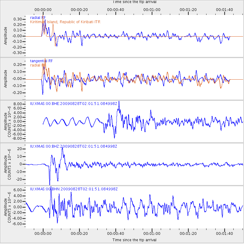
Signal To Noise
| Channel | StoN | STA | LTA |
| IU:XMAS:00:BHZ:20090828T02:01:51.084998Z | 6.094795 | 7.4883E-6 | 1.2286384E-6 |
| IU:XMAS:00:BHN:20090828T02:01:51.084998Z | 1.7516055 | 2.402242E-6 | 1.3714514E-6 |
| IU:XMAS:00:BHE:20090828T02:01:51.084998Z | 1.6492687 | 1.8389612E-6 | 1.1150162E-6 |
| Arrivals |
| Ps | |
| PpPs | |
| PsPs/PpSs | |


