You are here: Home > Network List > TA - USArray Transportable Network (new EarthScope stations) Stations List
> Station H53A Bobcaygeon, ON, CAN > Earthquake Result Viewer
H53A Bobcaygeon, ON, CAN - Earthquake Result Viewer
| Earthquake location: |
Alaska Peninsula |
| Earthquake latitude/longitude: |
56.7/-156.5 |
| Earthquake time(UTC): |
2015/05/29 (149) 07:00:08 GMT |
| Earthquake Depth: |
62 km |
| Earthquake Magnitude: |
6.8 MWP, 6.8 MI |
| Earthquake Catalog/Contributor: |
NEIC PDE/NEIC COMCAT |
|
| Network: |
TA USArray Transportable Network (new EarthScope stations) |
| Station: |
H53A Bobcaygeon, ON, CAN |
| Lat/Lon: |
44.57 N/78.58 W |
| Elevation: |
292 m |
|
| Distance: |
48.3 deg |
| Az: |
69.495 deg |
| Baz: |
313.697 deg |
| Ray Param: |
0.06929617 |
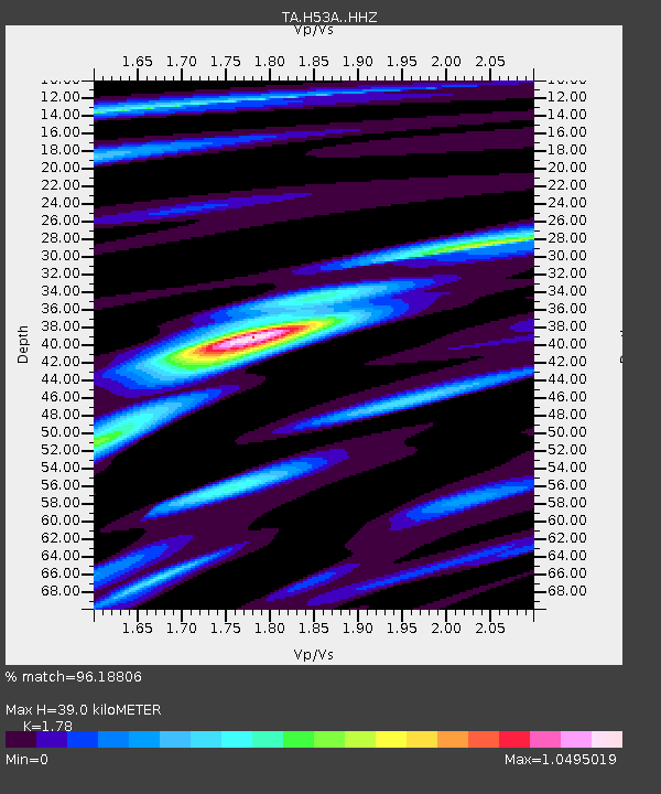
| Estimated Moho Depth: |
39.0 km |
| Estimated Crust Vp/Vs: |
1.78 |
| Assumed Crust Vp: |
6.577 km/s |
| Estimated Crust Vs: |
3.695 km/s |
| Estimated Crust Poisson's Ratio: |
0.27 |
|
| Radial Match: |
96.18806 % |
| Radial Bump: |
293 |
| Transverse Match: |
79.103424 % |
| Transverse Bump: |
400 |
| SOD ConfigId: |
7422571 |
| Insert Time: |
2019-04-19 02:43:38.157 +0000 |
| GWidth: |
2.5 |
| Max Bumps: |
400 |
| Tol: |
0.001 |
|
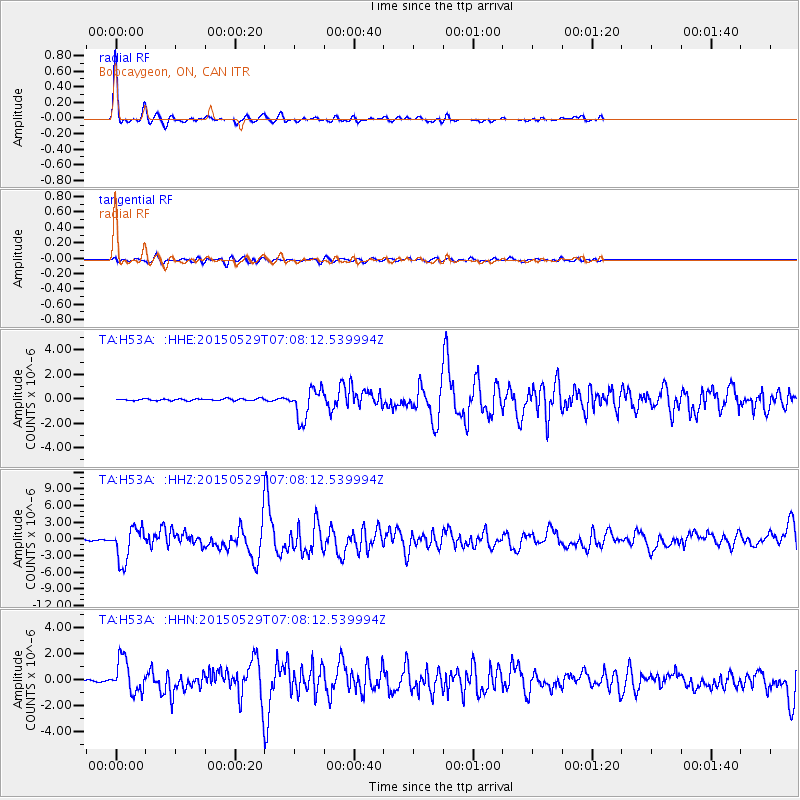
Signal To Noise
| Channel | StoN | STA | LTA |
| TA:H53A: :HHZ:20150529T07:08:12.539994Z | 33.562874 | 3.0425902E-6 | 9.0653444E-8 |
| TA:H53A: :HHN:20150529T07:08:12.539994Z | 23.29841 | 1.2777218E-6 | 5.484159E-8 |
| TA:H53A: :HHE:20150529T07:08:12.539994Z | 17.39815 | 1.2614944E-6 | 7.250739E-8 |
| Arrivals |
| Ps | 4.9 SECOND |
| PpPs | 15 SECOND |
| PsPs/PpSs | 20 SECOND |


