You are here: Home > Network List > TA - USArray Transportable Network (new EarthScope stations) Stations List
> Station H62A Milan, NH, USA > Earthquake Result Viewer
H62A Milan, NH, USA - Earthquake Result Viewer
| Earthquake location: |
Alaska Peninsula |
| Earthquake latitude/longitude: |
56.7/-156.5 |
| Earthquake time(UTC): |
2015/05/29 (149) 07:00:08 GMT |
| Earthquake Depth: |
62 km |
| Earthquake Magnitude: |
6.8 MWP, 6.8 MI |
| Earthquake Catalog/Contributor: |
NEIC PDE/NEIC COMCAT |
|
| Network: |
TA USArray Transportable Network (new EarthScope stations) |
| Station: |
H62A Milan, NH, USA |
| Lat/Lon: |
44.57 N/71.16 W |
| Elevation: |
381 m |
|
| Distance: |
52.0 deg |
| Az: |
64.63 deg |
| Baz: |
315.775 deg |
| Ray Param: |
0.0668505 |
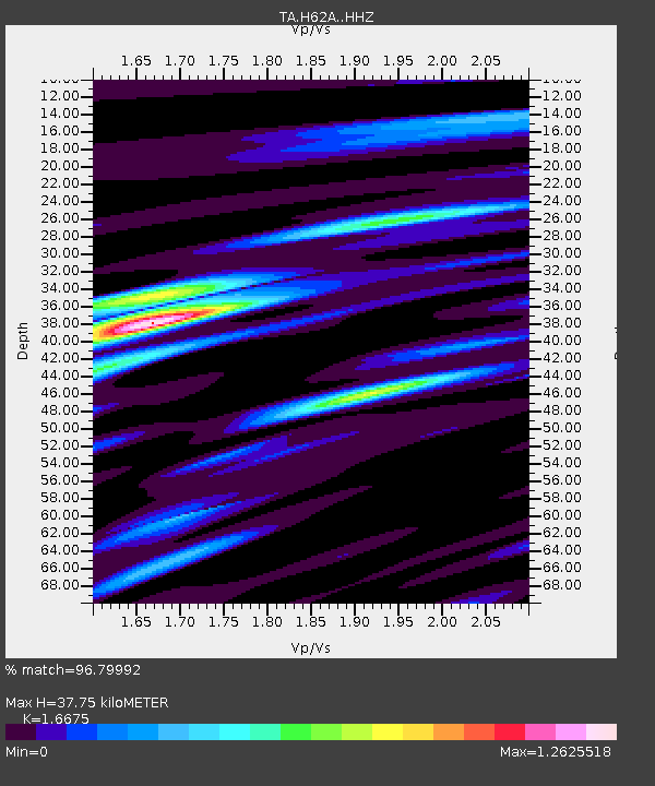
| Estimated Moho Depth: |
37.75 km |
| Estimated Crust Vp/Vs: |
1.67 |
| Assumed Crust Vp: |
6.419 km/s |
| Estimated Crust Vs: |
3.85 km/s |
| Estimated Crust Poisson's Ratio: |
0.22 |
|
| Radial Match: |
96.79992 % |
| Radial Bump: |
373 |
| Transverse Match: |
87.86459 % |
| Transverse Bump: |
400 |
| SOD ConfigId: |
7422571 |
| Insert Time: |
2019-04-19 02:43:42.875 +0000 |
| GWidth: |
2.5 |
| Max Bumps: |
400 |
| Tol: |
0.001 |
|
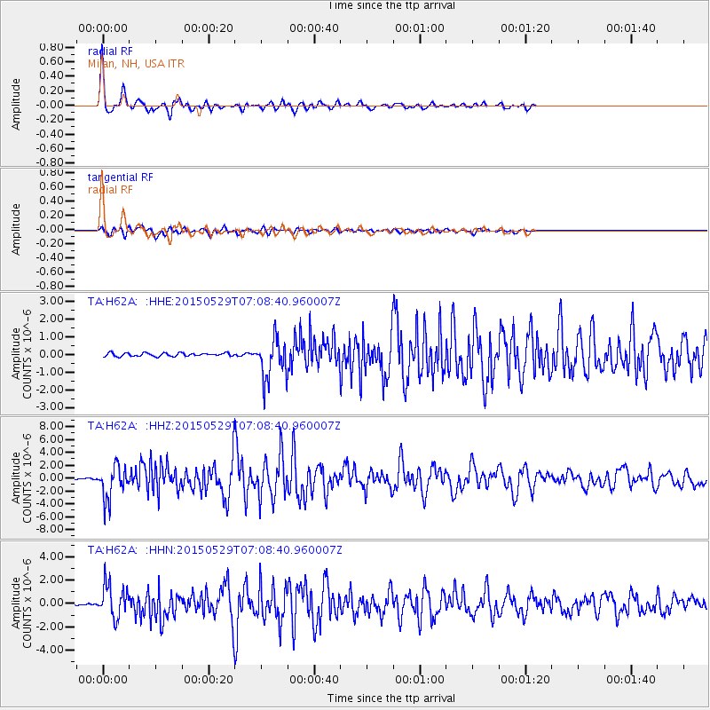
Signal To Noise
| Channel | StoN | STA | LTA |
| TA:H62A: :HHZ:20150529T07:08:40.960007Z | 19.631807 | 2.6069406E-6 | 1.3279167E-7 |
| TA:H62A: :HHN:20150529T07:08:40.960007Z | 14.549674 | 1.4227826E-6 | 9.778793E-8 |
| TA:H62A: :HHE:20150529T07:08:40.960007Z | 13.224774 | 1.1894331E-6 | 8.993976E-8 |
| Arrivals |
| Ps | 4.2 SECOND |
| PpPs | 15 SECOND |
| PsPs/PpSs | 19 SECOND |


