You are here: Home > Network List > TA - USArray Transportable Network (new EarthScope stations) Stations List
> Station H65A Eastbrook, ME, USA > Earthquake Result Viewer
H65A Eastbrook, ME, USA - Earthquake Result Viewer
| Earthquake location: |
Alaska Peninsula |
| Earthquake latitude/longitude: |
56.7/-156.5 |
| Earthquake time(UTC): |
2015/05/29 (149) 07:00:08 GMT |
| Earthquake Depth: |
62 km |
| Earthquake Magnitude: |
6.8 MWP, 6.8 MI |
| Earthquake Catalog/Contributor: |
NEIC PDE/NEIC COMCAT |
|
| Network: |
TA USArray Transportable Network (new EarthScope stations) |
| Station: |
H65A Eastbrook, ME, USA |
| Lat/Lon: |
44.70 N/68.25 W |
| Elevation: |
98 m |
|
| Distance: |
53.4 deg |
| Az: |
62.64 deg |
| Baz: |
316.606 deg |
| Ray Param: |
0.06596383 |
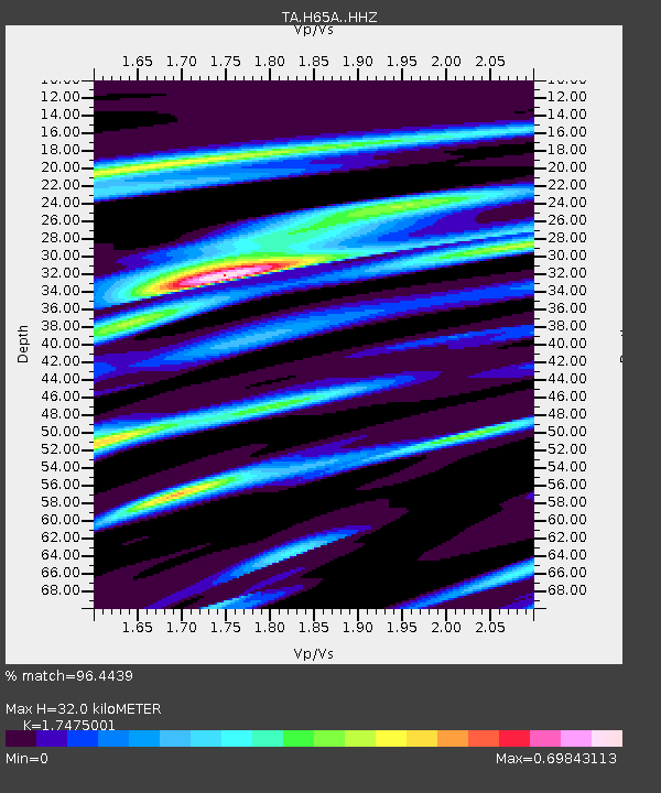
| Estimated Moho Depth: |
32.0 km |
| Estimated Crust Vp/Vs: |
1.75 |
| Assumed Crust Vp: |
6.419 km/s |
| Estimated Crust Vs: |
3.673 km/s |
| Estimated Crust Poisson's Ratio: |
0.26 |
|
| Radial Match: |
96.4439 % |
| Radial Bump: |
297 |
| Transverse Match: |
89.44225 % |
| Transverse Bump: |
400 |
| SOD ConfigId: |
7422571 |
| Insert Time: |
2019-04-19 02:43:43.709 +0000 |
| GWidth: |
2.5 |
| Max Bumps: |
400 |
| Tol: |
0.001 |
|

Signal To Noise
| Channel | StoN | STA | LTA |
| TA:H65A: :HHZ:20150529T07:08:50.87999Z | 13.896608 | 2.46939E-6 | 1.7769732E-7 |
| TA:H65A: :HHN:20150529T07:08:50.87999Z | 11.8555 | 9.866401E-7 | 8.322213E-8 |
| TA:H65A: :HHE:20150529T07:08:50.87999Z | 7.745768 | 8.8810754E-7 | 1.14657134E-7 |
| Arrivals |
| Ps | 3.9 SECOND |
| PpPs | 13 SECOND |
| PsPs/PpSs | 17 SECOND |


