You are here: Home > Network List > TA - USArray Transportable Network (new EarthScope stations) Stations List
> Station I58A Old Forge, NY, USA > Earthquake Result Viewer
I58A Old Forge, NY, USA - Earthquake Result Viewer
| Earthquake location: |
Alaska Peninsula |
| Earthquake latitude/longitude: |
56.7/-156.5 |
| Earthquake time(UTC): |
2015/05/29 (149) 07:00:08 GMT |
| Earthquake Depth: |
62 km |
| Earthquake Magnitude: |
6.8 MWP, 6.8 MI |
| Earthquake Catalog/Contributor: |
NEIC PDE/NEIC COMCAT |
|
| Network: |
TA USArray Transportable Network (new EarthScope stations) |
| Station: |
I58A Old Forge, NY, USA |
| Lat/Lon: |
43.69 N/74.97 W |
| Elevation: |
599 m |
|
| Distance: |
50.7 deg |
| Az: |
67.931 deg |
| Baz: |
315.186 deg |
| Ray Param: |
0.067686215 |
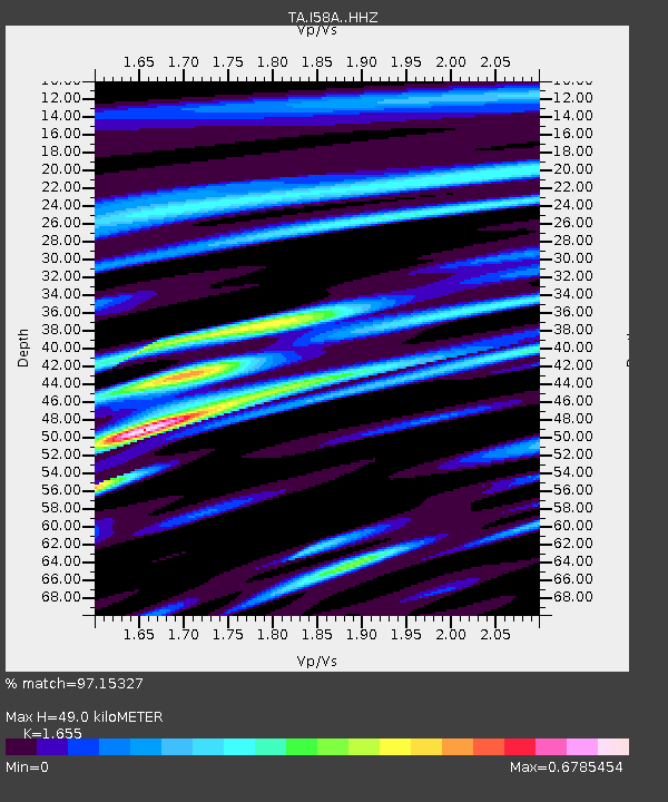
| Estimated Moho Depth: |
49.0 km |
| Estimated Crust Vp/Vs: |
1.65 |
| Assumed Crust Vp: |
6.419 km/s |
| Estimated Crust Vs: |
3.879 km/s |
| Estimated Crust Poisson's Ratio: |
0.21 |
|
| Radial Match: |
97.15327 % |
| Radial Bump: |
311 |
| Transverse Match: |
86.309 % |
| Transverse Bump: |
400 |
| SOD ConfigId: |
7422571 |
| Insert Time: |
2019-04-19 02:43:47.642 +0000 |
| GWidth: |
2.5 |
| Max Bumps: |
400 |
| Tol: |
0.001 |
|
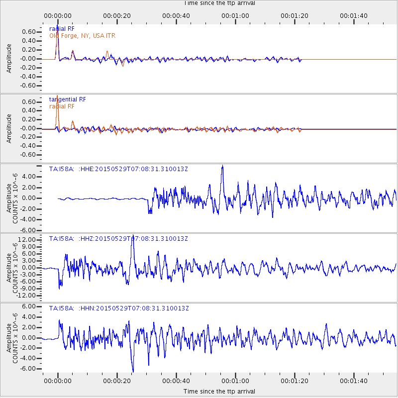
Signal To Noise
| Channel | StoN | STA | LTA |
| TA:I58A: :HHZ:20150529T07:08:31.310013Z | 40.747185 | 3.7472983E-6 | 9.19646E-8 |
| TA:I58A: :HHN:20150529T07:08:31.310013Z | 24.067247 | 1.5156558E-6 | 6.297587E-8 |
| TA:I58A: :HHE:20150529T07:08:31.310013Z | 16.427406 | 1.3608957E-6 | 8.2843E-8 |
| Arrivals |
| Ps | 5.3 SECOND |
| PpPs | 19 SECOND |
| PsPs/PpSs | 24 SECOND |


