You are here: Home > Network List > IU - Global Seismograph Network (GSN - IRIS/USGS) Stations List
> Station XMAS Kiritimati Island, Republic of Kiribati > Earthquake Result Viewer
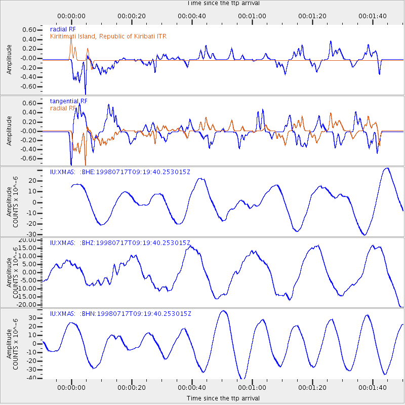
XMAS Kiritimati Island, Republic of Kiribati - Earthquake Result Viewer
*The percent match for this event was below the threshold and hence no stack was calculated.
| Earthquake location: |
Near N Coast Of New Guinea, P.N.G. |
| Earthquake latitude/longitude: |
-2.9/142.4 |
| Earthquake time(UTC): |
1998/07/17 (198) 09:10:02 GMT |
| Earthquake Depth: |
10 km |
| Earthquake Magnitude: |
5.9 MB |
| Earthquake Catalog/Contributor: |
WHDF/NEIC |
|
| Network: |
IU Global Seismograph Network (GSN - IRIS/USGS) |
| Station: |
XMAS Kiritimati Island, Republic of Kiribati |
| Lat/Lon: |
2.04 N/157.45 W |
| Elevation: |
2.0 m |
|
| Distance: |
60.4 deg |
| Az: |
86.023 deg |
| Baz: |
265.535 deg |
| Ray Param: |
$rayparam |
*The percent match for this event was below the threshold and hence was not used in the summary stack. |
|
| Radial Match: |
73.93788 % |
| Radial Bump: |
400 |
| Transverse Match: |
42.32129 % |
| Transverse Bump: |
400 |
| SOD ConfigId: |
4480 |
| Insert Time: |
2010-03-02 15:50:25.090 +0000 |
| GWidth: |
2.5 |
| Max Bumps: |
400 |
| Tol: |
0.001 |
|
Signal To Noise
| Channel | StoN | STA | LTA |
| IU:XMAS: :BHZ:19980717T09:19:40.253015Z | 0.8224355 | 5.0149265E-6 | 6.097653E-6 |
| IU:XMAS: :BHN:19980717T09:19:40.253015Z | 1.9772693 | 1.9920406E-5 | 1.0074706E-5 |
| IU:XMAS: :BHE:19980717T09:19:40.253015Z | 0.8934208 | 1.0497232E-5 | 1.1749482E-5 |
| Arrivals |
| Ps | |
| PpPs | |
| PsPs/PpSs | |


