You are here: Home > Network List > TA - USArray Transportable Network (new EarthScope stations) Stations List
> Station J58A Remsen, NY, USA > Earthquake Result Viewer
J58A Remsen, NY, USA - Earthquake Result Viewer
| Earthquake location: |
Alaska Peninsula |
| Earthquake latitude/longitude: |
56.7/-156.5 |
| Earthquake time(UTC): |
2015/05/29 (149) 07:00:08 GMT |
| Earthquake Depth: |
62 km |
| Earthquake Magnitude: |
6.8 MWP, 6.8 MI |
| Earthquake Catalog/Contributor: |
NEIC PDE/NEIC COMCAT |
|
| Network: |
TA USArray Transportable Network (new EarthScope stations) |
| Station: |
J58A Remsen, NY, USA |
| Lat/Lon: |
43.36 N/75.29 W |
| Elevation: |
436 m |
|
| Distance: |
50.8 deg |
| Az: |
68.439 deg |
| Baz: |
315.293 deg |
| Ray Param: |
0.067640014 |
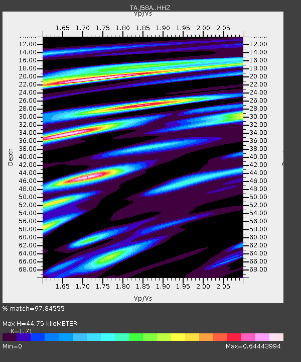
| Estimated Moho Depth: |
44.75 km |
| Estimated Crust Vp/Vs: |
1.71 |
| Assumed Crust Vp: |
6.419 km/s |
| Estimated Crust Vs: |
3.754 km/s |
| Estimated Crust Poisson's Ratio: |
0.24 |
|
| Radial Match: |
97.84555 % |
| Radial Bump: |
281 |
| Transverse Match: |
92.068726 % |
| Transverse Bump: |
400 |
| SOD ConfigId: |
7422571 |
| Insert Time: |
2019-04-19 02:43:53.828 +0000 |
| GWidth: |
2.5 |
| Max Bumps: |
400 |
| Tol: |
0.001 |
|

Signal To Noise
| Channel | StoN | STA | LTA |
| TA:J58A: :HHZ:20150529T07:08:31.870011Z | 59.25197 | 4.661999E-6 | 7.8680905E-8 |
| TA:J58A: :HHN:20150529T07:08:31.870011Z | 27.80321 | 1.937082E-6 | 6.967117E-8 |
| TA:J58A: :HHE:20150529T07:08:31.870011Z | 30.245756 | 1.8421656E-6 | 6.090658E-8 |
| Arrivals |
| Ps | 5.3 SECOND |
| PpPs | 18 SECOND |
| PsPs/PpSs | 23 SECOND |


