You are here: Home > Network List > TA - USArray Transportable Network (new EarthScope stations) Stations List
> Station MDND Maddock, ND, USA > Earthquake Result Viewer
MDND Maddock, ND, USA - Earthquake Result Viewer
| Earthquake location: |
Alaska Peninsula |
| Earthquake latitude/longitude: |
56.7/-156.5 |
| Earthquake time(UTC): |
2015/05/29 (149) 07:00:08 GMT |
| Earthquake Depth: |
62 km |
| Earthquake Magnitude: |
6.8 MWP, 6.8 MI |
| Earthquake Catalog/Contributor: |
NEIC PDE/NEIC COMCAT |
|
| Network: |
TA USArray Transportable Network (new EarthScope stations) |
| Station: |
MDND Maddock, ND, USA |
| Lat/Lon: |
47.85 N/99.60 W |
| Elevation: |
479 m |
|
| Distance: |
35.0 deg |
| Az: |
79.836 deg |
| Baz: |
306.274 deg |
| Ray Param: |
0.07729126 |
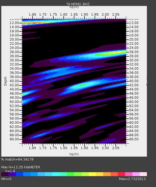
| Estimated Moho Depth: |
12.25 km |
| Estimated Crust Vp/Vs: |
1.60 |
| Assumed Crust Vp: |
6.53 km/s |
| Estimated Crust Vs: |
4.082 km/s |
| Estimated Crust Poisson's Ratio: |
0.18 |
|
| Radial Match: |
94.34179 % |
| Radial Bump: |
400 |
| Transverse Match: |
74.690765 % |
| Transverse Bump: |
400 |
| SOD ConfigId: |
7422571 |
| Insert Time: |
2019-04-19 02:44:21.148 +0000 |
| GWidth: |
2.5 |
| Max Bumps: |
400 |
| Tol: |
0.001 |
|
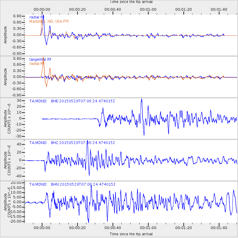
Signal To Noise
| Channel | StoN | STA | LTA |
| TA:MDND: :BHZ:20150529T07:06:24.474015Z | 73.86423 | 9.87006E-6 | 1.3362435E-7 |
| TA:MDND: :BHN:20150529T07:06:24.474015Z | 16.633451 | 5.7364905E-6 | 3.4487672E-7 |
| TA:MDND: :BHE:20150529T07:06:24.474015Z | 29.316397 | 7.1637355E-6 | 2.4435934E-7 |
| Arrivals |
| Ps | 1.2 SECOND |
| PpPs | 4.5 SECOND |
| PsPs/PpSs | 5.7 SECOND |


