You are here: Home > Network List > TA - USArray Transportable Network (new EarthScope stations) Stations List
> Station N62A Caumsett State Park, Huntington, NY, USA > Earthquake Result Viewer
N62A Caumsett State Park, Huntington, NY, USA - Earthquake Result Viewer
| Earthquake location: |
Alaska Peninsula |
| Earthquake latitude/longitude: |
56.7/-156.5 |
| Earthquake time(UTC): |
2015/05/29 (149) 07:00:08 GMT |
| Earthquake Depth: |
62 km |
| Earthquake Magnitude: |
6.8 MWP, 6.8 MI |
| Earthquake Catalog/Contributor: |
NEIC PDE/NEIC COMCAT |
|
| Network: |
TA USArray Transportable Network (new EarthScope stations) |
| Station: |
N62A Caumsett State Park, Huntington, NY, USA |
| Lat/Lon: |
40.93 N/73.47 W |
| Elevation: |
34 m |
|
| Distance: |
53.5 deg |
| Az: |
69.332 deg |
| Baz: |
317.057 deg |
| Ray Param: |
0.06588772 |
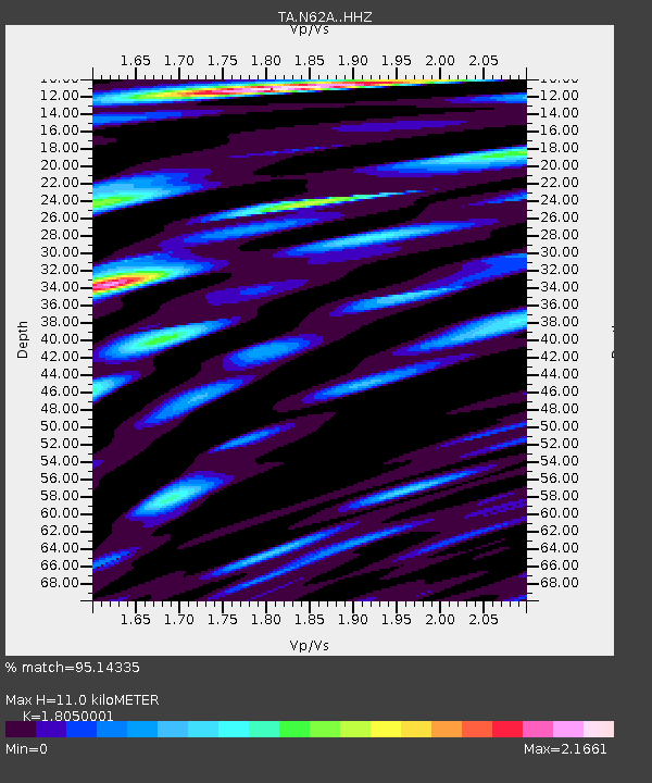
| Estimated Moho Depth: |
11.0 km |
| Estimated Crust Vp/Vs: |
1.81 |
| Assumed Crust Vp: |
6.472 km/s |
| Estimated Crust Vs: |
3.586 km/s |
| Estimated Crust Poisson's Ratio: |
0.28 |
|
| Radial Match: |
95.14335 % |
| Radial Bump: |
400 |
| Transverse Match: |
84.3086 % |
| Transverse Bump: |
400 |
| SOD ConfigId: |
7422571 |
| Insert Time: |
2019-04-19 02:44:25.435 +0000 |
| GWidth: |
2.5 |
| Max Bumps: |
400 |
| Tol: |
0.001 |
|

Signal To Noise
| Channel | StoN | STA | LTA |
| TA:N62A: :HHZ:20150529T07:08:51.749985Z | 31.536303 | 3.817064E-6 | 1.2103715E-7 |
| TA:N62A: :HHN:20150529T07:08:51.749985Z | 24.272024 | 3.588851E-6 | 1.4785957E-7 |
| TA:N62A: :HHE:20150529T07:08:51.749985Z | 16.47571 | 2.188293E-6 | 1.3281934E-7 |
| Arrivals |
| Ps | 1.4 SECOND |
| PpPs | 4.5 SECOND |
| PsPs/PpSs | 6.0 SECOND |


