You are here: Home > Network List > TA - USArray Transportable Network (new EarthScope stations) Stations List
> Station Q24A Divide, CO, USA > Earthquake Result Viewer
Q24A Divide, CO, USA - Earthquake Result Viewer
| Earthquake location: |
Alaska Peninsula |
| Earthquake latitude/longitude: |
56.7/-156.5 |
| Earthquake time(UTC): |
2015/05/29 (149) 07:00:08 GMT |
| Earthquake Depth: |
62 km |
| Earthquake Magnitude: |
6.8 MWP, 6.8 MI |
| Earthquake Catalog/Contributor: |
NEIC PDE/NEIC COMCAT |
|
| Network: |
TA USArray Transportable Network (new EarthScope stations) |
| Station: |
Q24A Divide, CO, USA |
| Lat/Lon: |
38.96 N/105.15 W |
| Elevation: |
2775 m |
|
| Distance: |
37.7 deg |
| Az: |
95.656 deg |
| Baz: |
315.234 deg |
| Ray Param: |
0.07578577 |
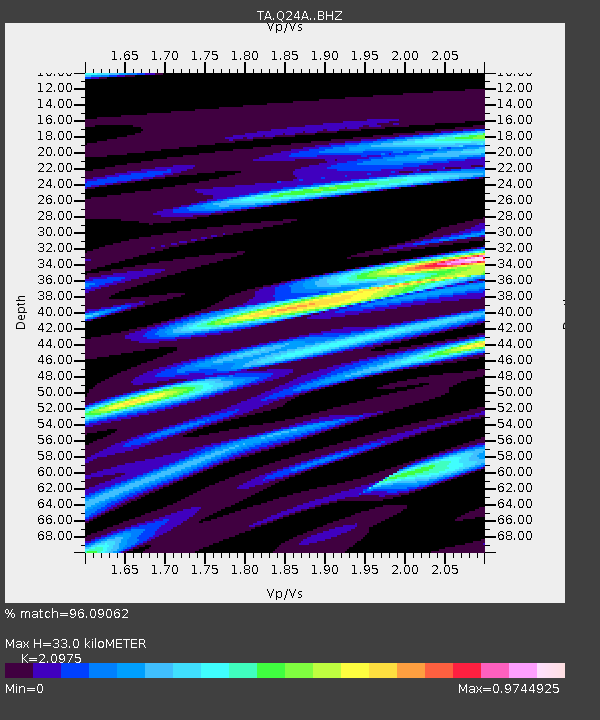
| Estimated Moho Depth: |
33.0 km |
| Estimated Crust Vp/Vs: |
2.10 |
| Assumed Crust Vp: |
6.159 km/s |
| Estimated Crust Vs: |
2.936 km/s |
| Estimated Crust Poisson's Ratio: |
0.35 |
|
| Radial Match: |
96.09062 % |
| Radial Bump: |
341 |
| Transverse Match: |
86.45257 % |
| Transverse Bump: |
400 |
| SOD ConfigId: |
7422571 |
| Insert Time: |
2019-04-19 02:44:31.980 +0000 |
| GWidth: |
2.5 |
| Max Bumps: |
400 |
| Tol: |
0.001 |
|

Signal To Noise
| Channel | StoN | STA | LTA |
| TA:Q24A: :BHZ:20150529T07:06:47.874985Z | 78.852745 | 5.2628716E-6 | 6.6743034E-8 |
| TA:Q24A: :BHN:20150529T07:06:47.874985Z | 40.34678 | 2.639404E-6 | 6.5417964E-8 |
| TA:Q24A: :BHE:20150529T07:06:47.874985Z | 36.116478 | 2.105221E-6 | 5.828977E-8 |
| Arrivals |
| Ps | 6.2 SECOND |
| PpPs | 16 SECOND |
| PsPs/PpSs | 22 SECOND |


