You are here: Home > Network List > IU - Global Seismograph Network (GSN - IRIS/USGS) Stations List
> Station XMAS Kiritimati Island, Republic of Kiribati > Earthquake Result Viewer
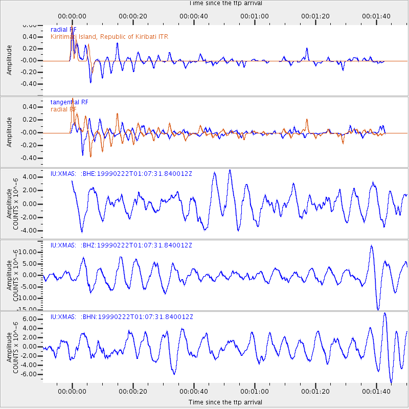
XMAS Kiritimati Island, Republic of Kiribati - Earthquake Result Viewer
*The percent match for this event was below the threshold and hence no stack was calculated.
| Earthquake location: |
Southeast Of Loyalty Islands |
| Earthquake latitude/longitude: |
-21.5/169.7 |
| Earthquake time(UTC): |
1999/02/22 (053) 01:00:32 GMT |
| Earthquake Depth: |
33 km |
| Earthquake Magnitude: |
5.8 MB, 6.4 MS, 6.5 MW, 6.4 MW |
| Earthquake Catalog/Contributor: |
WHDF/NEIC |
|
| Network: |
IU Global Seismograph Network (GSN - IRIS/USGS) |
| Station: |
XMAS Kiritimati Island, Republic of Kiribati |
| Lat/Lon: |
2.04 N/157.45 W |
| Elevation: |
2.0 m |
|
| Distance: |
39.7 deg |
| Az: |
58.057 deg |
| Baz: |
232.278 deg |
| Ray Param: |
$rayparam |
*The percent match for this event was below the threshold and hence was not used in the summary stack. |
|
| Radial Match: |
72.19857 % |
| Radial Bump: |
400 |
| Transverse Match: |
63.524574 % |
| Transverse Bump: |
400 |
| SOD ConfigId: |
4480 |
| Insert Time: |
2010-03-02 15:50:45.638 +0000 |
| GWidth: |
2.5 |
| Max Bumps: |
400 |
| Tol: |
0.001 |
|
Signal To Noise
| Channel | StoN | STA | LTA |
| IU:XMAS: :BHZ:19990222T01:07:31.840012Z | 3.6164389 | 3.6971906E-6 | 1.022329E-6 |
| IU:XMAS: :BHN:19990222T01:07:31.840012Z | 2.3209229 | 2.2050667E-6 | 9.500818E-7 |
| IU:XMAS: :BHE:19990222T01:07:31.840012Z | 0.6407082 | 9.830046E-7 | 1.5342468E-6 |
| Arrivals |
| Ps | |
| PpPs | |
| PsPs/PpSs | |


