You are here: Home > Network List > TO - Tectonic Observatory Stations List
> Station CC10 CCSE CC10 > Earthquake Result Viewer
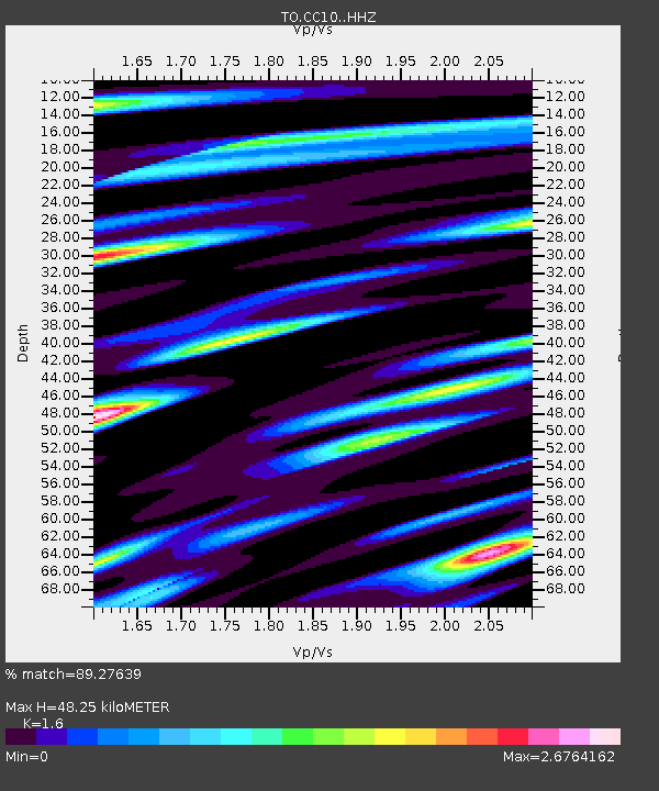
CC10 CCSE CC10 - Earthquake Result Viewer
| Earthquake location: |
Alaska Peninsula |
| Earthquake latitude/longitude: |
56.7/-156.5 |
| Earthquake time(UTC): |
2015/05/29 (149) 07:00:08 GMT |
| Earthquake Depth: |
62 km |
| Earthquake Magnitude: |
6.8 MWP, 6.8 MI |
| Earthquake Catalog/Contributor: |
NEIC PDE/NEIC COMCAT |
|
| Network: |
TO Tectonic Observatory |
| Station: |
CC10 CCSE CC10 |
| Lat/Lon: |
36.05 N/120.82 W |
| Elevation: |
225 m |
|
| Distance: |
31.6 deg |
| Az: |
115.507 deg |
| Baz: |
322.092 deg |
| Ray Param: |
0.07886605 |
| Estimated Moho Depth: |
48.25 km |
| Estimated Crust Vp/Vs: |
1.60 |
| Assumed Crust Vp: |
6.391 km/s |
| Estimated Crust Vs: |
3.994 km/s |
| Estimated Crust Poisson's Ratio: |
0.18 |
|
| Radial Match: |
89.27639 % |
| Radial Bump: |
400 |
| Transverse Match: |
70.90168 % |
| Transverse Bump: |
400 |
| SOD ConfigId: |
7422571 |
| Insert Time: |
2019-04-19 02:45:01.276 +0000 |
| GWidth: |
2.5 |
| Max Bumps: |
400 |
| Tol: |
0.001 |
|

Signal To Noise
| Channel | StoN | STA | LTA |
| TO:CC10: :HHZ:20150529T07:05:55.120011Z | 18.799582 | 5.633309E-6 | 2.9965074E-7 |
| TO:CC10: :HHN:20150529T07:05:55.120011Z | 6.4674954 | 2.8587715E-6 | 4.4202142E-7 |
| TO:CC10: :HHE:20150529T07:05:55.120011Z | 8.322801 | 2.75649E-6 | 3.311974E-7 |
| Arrivals |
| Ps | 4.9 SECOND |
| PpPs | 18 SECOND |
| PsPs/PpSs | 23 SECOND |


