You are here: Home > Network List > TO - Tectonic Observatory Stations List
> Station CC33 CCSE CC33 > Earthquake Result Viewer
CC33 CCSE CC33 - Earthquake Result Viewer
| Earthquake location: |
Alaska Peninsula |
| Earthquake latitude/longitude: |
56.7/-156.5 |
| Earthquake time(UTC): |
2015/05/29 (149) 07:00:08 GMT |
| Earthquake Depth: |
62 km |
| Earthquake Magnitude: |
6.8 MWP, 6.8 MI |
| Earthquake Catalog/Contributor: |
NEIC PDE/NEIC COMCAT |
|
| Network: |
TO Tectonic Observatory |
| Station: |
CC33 CCSE CC33 |
| Lat/Lon: |
36.34 N/119.12 W |
| Elevation: |
126 m |
|
| Distance: |
32.2 deg |
| Az: |
113.117 deg |
| Baz: |
321.064 deg |
| Ray Param: |
0.07860223 |
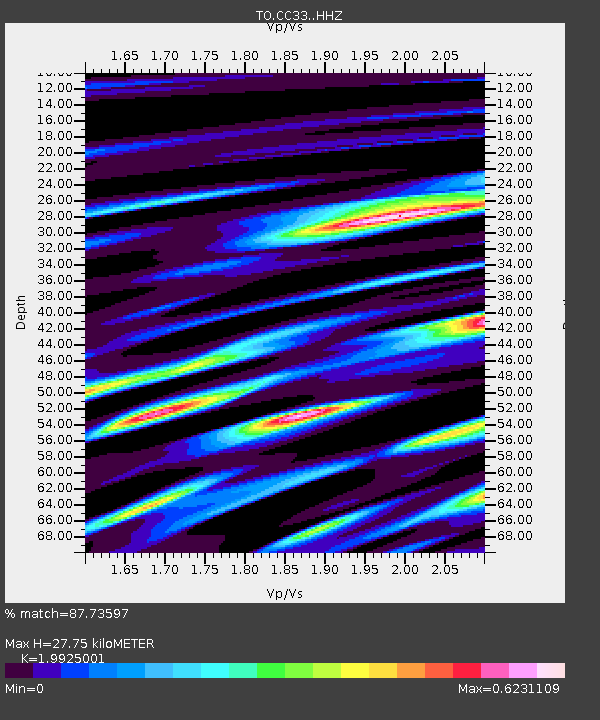
| Estimated Moho Depth: |
27.75 km |
| Estimated Crust Vp/Vs: |
1.99 |
| Assumed Crust Vp: |
6.291 km/s |
| Estimated Crust Vs: |
3.157 km/s |
| Estimated Crust Poisson's Ratio: |
0.33 |
|
| Radial Match: |
87.73597 % |
| Radial Bump: |
221 |
| Transverse Match: |
81.75769 % |
| Transverse Bump: |
400 |
| SOD ConfigId: |
7422571 |
| Insert Time: |
2019-04-19 02:45:14.695 +0000 |
| GWidth: |
2.5 |
| Max Bumps: |
400 |
| Tol: |
0.001 |
|

Signal To Noise
| Channel | StoN | STA | LTA |
| TO:CC33: :HHZ:20150529T07:06:00.569993Z | 42.177402 | 5.6955323E-6 | 1.3503754E-7 |
| TO:CC33: :HHN:20150529T07:06:00.569993Z | 38.0103 | 3.7426819E-6 | 9.8464945E-8 |
| TO:CC33: :HHE:20150529T07:06:00.569993Z | 19.183554 | 2.8752747E-6 | 1.4988227E-7 |
| Arrivals |
| Ps | 4.7 SECOND |
| PpPs | 12 SECOND |
| PsPs/PpSs | 17 SECOND |


