You are here: Home > Network List > TO - Tectonic Observatory Stations List
> Station CC35 CCSE CC35 > Earthquake Result Viewer
CC35 CCSE CC35 - Earthquake Result Viewer
| Earthquake location: |
Alaska Peninsula |
| Earthquake latitude/longitude: |
56.7/-156.5 |
| Earthquake time(UTC): |
2015/05/29 (149) 07:00:08 GMT |
| Earthquake Depth: |
62 km |
| Earthquake Magnitude: |
6.8 MWP, 6.8 MI |
| Earthquake Catalog/Contributor: |
NEIC PDE/NEIC COMCAT |
|
| Network: |
TO Tectonic Observatory |
| Station: |
CC35 CCSE CC35 |
| Lat/Lon: |
36.38 N/119.01 W |
| Elevation: |
194 m |
|
| Distance: |
32.3 deg |
| Az: |
112.943 deg |
| Baz: |
320.986 deg |
| Ray Param: |
0.078587435 |
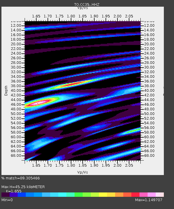
| Estimated Moho Depth: |
45.25 km |
| Estimated Crust Vp/Vs: |
1.65 |
| Assumed Crust Vp: |
6.291 km/s |
| Estimated Crust Vs: |
3.801 km/s |
| Estimated Crust Poisson's Ratio: |
0.21 |
|
| Radial Match: |
89.305466 % |
| Radial Bump: |
372 |
| Transverse Match: |
73.95209 % |
| Transverse Bump: |
400 |
| SOD ConfigId: |
7422571 |
| Insert Time: |
2019-04-19 02:45:16.341 +0000 |
| GWidth: |
2.5 |
| Max Bumps: |
400 |
| Tol: |
0.001 |
|

Signal To Noise
| Channel | StoN | STA | LTA |
| TO:CC35: :HHZ:20150529T07:06:00.870011Z | 27.787252 | 4.526157E-6 | 1.6288611E-7 |
| TO:CC35: :HHN:20150529T07:06:00.870011Z | 32.21414 | 2.6614186E-6 | 8.261647E-8 |
| TO:CC35: :HHE:20150529T07:06:00.870011Z | 22.485865 | 2.2652255E-6 | 1.0073998E-7 |
| Arrivals |
| Ps | 5.1 SECOND |
| PpPs | 18 SECOND |
| PsPs/PpSs | 23 SECOND |


