You are here: Home > Network List > TO - Tectonic Observatory Stations List
> Station CC36 CCSE CC36 > Earthquake Result Viewer
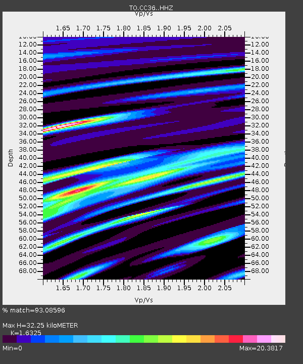
CC36 CCSE CC36 - Earthquake Result Viewer
| Earthquake location: |
Alaska Peninsula |
| Earthquake latitude/longitude: |
56.7/-156.5 |
| Earthquake time(UTC): |
2015/05/29 (149) 07:00:08 GMT |
| Earthquake Depth: |
62 km |
| Earthquake Magnitude: |
6.8 MWP, 6.8 MI |
| Earthquake Catalog/Contributor: |
NEIC PDE/NEIC COMCAT |
|
| Network: |
TO Tectonic Observatory |
| Station: |
CC36 CCSE CC36 |
| Lat/Lon: |
36.39 N/118.96 W |
| Elevation: |
265 m |
|
| Distance: |
32.3 deg |
| Az: |
112.875 deg |
| Baz: |
320.954 deg |
| Ray Param: |
0.078582525 |
| Estimated Moho Depth: |
32.25 km |
| Estimated Crust Vp/Vs: |
1.63 |
| Assumed Crust Vp: |
6.291 km/s |
| Estimated Crust Vs: |
3.854 km/s |
| Estimated Crust Poisson's Ratio: |
0.20 |
|
| Radial Match: |
93.08596 % |
| Radial Bump: |
331 |
| Transverse Match: |
82.48636 % |
| Transverse Bump: |
400 |
| SOD ConfigId: |
7422571 |
| Insert Time: |
2019-04-19 02:45:18.125 +0000 |
| GWidth: |
2.5 |
| Max Bumps: |
400 |
| Tol: |
0.001 |
|

Signal To Noise
| Channel | StoN | STA | LTA |
| TO:CC36: :HHZ:20150529T07:06:00.979996Z | 36.51662 | 2.1518531E-7 | 5.8928045E-9 |
| TO:CC36: :HHN:20150529T07:06:00.979996Z | 25.129103 | 2.1010226E-6 | 8.360914E-8 |
| TO:CC36: :HHE:20150529T07:06:00.979996Z | 28.63093 | 2.7928472E-6 | 9.754651E-8 |
| Arrivals |
| Ps | 3.5 SECOND |
| PpPs | 12 SECOND |
| PsPs/PpSs | 16 SECOND |


