You are here: Home > Network List > IU - Global Seismograph Network (GSN - IRIS/USGS) Stations List
> Station XMAS Kiritimati Island, Republic of Kiribati > Earthquake Result Viewer
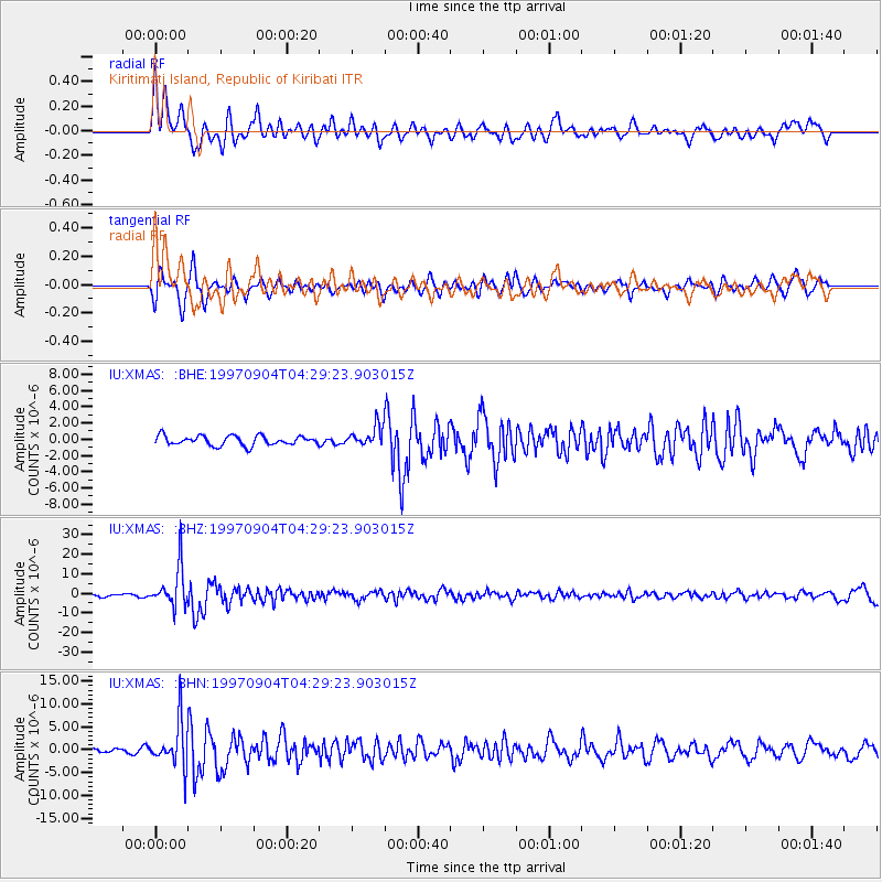
XMAS Kiritimati Island, Republic of Kiribati - Earthquake Result Viewer
*The percent match for this event was below the threshold and hence no stack was calculated.
| Earthquake location: |
South Of Fiji Islands |
| Earthquake latitude/longitude: |
-26.6/178.3 |
| Earthquake time(UTC): |
1997/09/04 (247) 04:23:37 GMT |
| Earthquake Depth: |
625 km |
| Earthquake Magnitude: |
6.3 MB, 6.8 UNKNOWN, 6.5 ME |
| Earthquake Catalog/Contributor: |
WHDF/NEIC |
|
| Network: |
IU Global Seismograph Network (GSN - IRIS/USGS) |
| Station: |
XMAS Kiritimati Island, Republic of Kiribati |
| Lat/Lon: |
2.04 N/157.45 W |
| Elevation: |
2.0 m |
|
| Distance: |
36.8 deg |
| Az: |
43.158 deg |
| Baz: |
217.805 deg |
| Ray Param: |
$rayparam |
*The percent match for this event was below the threshold and hence was not used in the summary stack. |
|
| Radial Match: |
76.85677 % |
| Radial Bump: |
400 |
| Transverse Match: |
70.34616 % |
| Transverse Bump: |
400 |
| SOD ConfigId: |
4480 |
| Insert Time: |
2010-03-02 15:50:54.204 +0000 |
| GWidth: |
2.5 |
| Max Bumps: |
400 |
| Tol: |
0.001 |
|
Signal To Noise
| Channel | StoN | STA | LTA |
| IU:XMAS: :BHZ:19970904T04:29:23.903015Z | 16.056862 | 1.0330452E-5 | 6.4336683E-7 |
| IU:XMAS: :BHN:19970904T04:29:23.903015Z | 7.1285763 | 4.8987895E-6 | 6.872045E-7 |
| IU:XMAS: :BHE:19970904T04:29:23.903015Z | 2.067722 | 1.2205953E-6 | 5.903092E-7 |
| Arrivals |
| Ps | |
| PpPs | |
| PsPs/PpSs | |


