You are here: Home > Network List > US - United States National Seismic Network Stations List
> Station RLMT Red Lodge, Montana, USA > Earthquake Result Viewer
RLMT Red Lodge, Montana, USA - Earthquake Result Viewer

| Earthquake location: |
Alaska Peninsula |
| Earthquake latitude/longitude: |
56.7/-156.5 |
| Earthquake time(UTC): |
2015/05/29 (149) 07:00:08 GMT |
| Earthquake Depth: |
62 km |
| Earthquake Magnitude: |
6.8 MWP, 6.8 MI |
| Earthquake Catalog/Contributor: |
NEIC PDE/NEIC COMCAT |
|
| Network: |
US United States National Seismic Network |
| Station: |
RLMT Red Lodge, Montana, USA |
| Lat/Lon: |
45.12 N/109.27 W |
| Elevation: |
2086 m |
|
| Distance: |
31.3 deg |
| Az: |
91.223 deg |
| Baz: |
308.824 deg |
| Ray Param: |
0.07897875 |
| Estimated Moho Depth: |
24.0 km |
| Estimated Crust Vp/Vs: |
1.75 |
| Assumed Crust Vp: |
6.242 km/s |
| Estimated Crust Vs: |
3.572 km/s |
| Estimated Crust Poisson's Ratio: |
0.26 |
|
| Radial Match: |
94.51235 % |
| Radial Bump: |
345 |
| Transverse Match: |
90.803604 % |
| Transverse Bump: |
400 |
| SOD ConfigId: |
7422571 |
| Insert Time: |
2019-04-19 02:45:34.950 +0000 |
| GWidth: |
2.5 |
| Max Bumps: |
400 |
| Tol: |
0.001 |
|
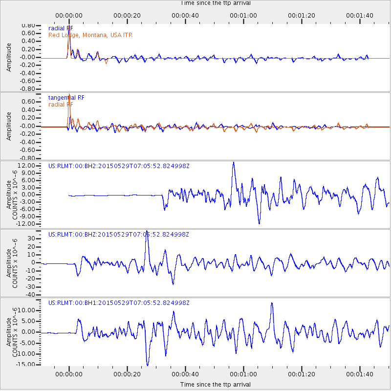
Signal To Noise
| Channel | StoN | STA | LTA |
| US:RLMT:00:BHZ:20150529T07:05:52.824998Z | 75.30288 | 6.538443E-6 | 8.682859E-8 |
| US:RLMT:00:BH1:20150529T07:05:52.824998Z | 44.136578 | 2.7120448E-6 | 6.144664E-8 |
| US:RLMT:00:BH2:20150529T07:05:52.824998Z | 22.130362 | 2.4857945E-6 | 1.12325075E-7 |
| Arrivals |
| Ps | 3.1 SECOND |
| PpPs | 9.8 SECOND |
| PsPs/PpSs | 13 SECOND |


