You are here: Home > Network List > IU - Global Seismograph Network (GSN - IRIS/USGS) Stations List
> Station XMAS Kiritimati Island, Republic of Kiribati > Earthquake Result Viewer
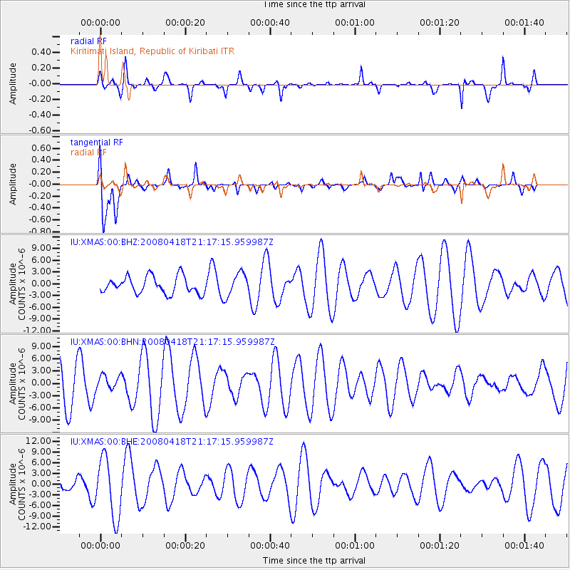
XMAS Kiritimati Island, Republic of Kiribati - Earthquake Result Viewer
*The percent match for this event was below the threshold and hence no stack was calculated.
| Earthquake location: |
Kermadec Islands Region |
| Earthquake latitude/longitude: |
-27.5/-176.6 |
| Earthquake time(UTC): |
2008/04/18 (109) 21:10:56 GMT |
| Earthquake Depth: |
10 km |
| Earthquake Magnitude: |
5.6 MS, 5.4 MB, 5.8 MW, 5.8 MW |
| Earthquake Catalog/Contributor: |
WHDF/NEIC |
|
| Network: |
IU Global Seismograph Network (GSN - IRIS/USGS) |
| Station: |
XMAS Kiritimati Island, Republic of Kiribati |
| Lat/Lon: |
2.04 N/157.45 W |
| Elevation: |
2.0 m |
|
| Distance: |
34.7 deg |
| Az: |
35.132 deg |
| Baz: |
210.755 deg |
| Ray Param: |
$rayparam |
*The percent match for this event was below the threshold and hence was not used in the summary stack. |
|
| Radial Match: |
64.29664 % |
| Radial Bump: |
269 |
| Transverse Match: |
51.202164 % |
| Transverse Bump: |
400 |
| SOD ConfigId: |
2504 |
| Insert Time: |
2010-03-02 15:51:05.031 +0000 |
| GWidth: |
2.5 |
| Max Bumps: |
400 |
| Tol: |
0.001 |
|
Signal To Noise
| Channel | StoN | STA | LTA |
| IU:XMAS:00:BHN:20080418T21:17:15.959987Z | 0.3843241 | 1.8331322E-6 | 4.769756E-6 |
| IU:XMAS:00:BHE:20080418T21:17:15.959987Z | 2.809964 | 8.54134E-6 | 3.039662E-6 |
| IU:XMAS:00:BHZ:20080418T21:17:15.959987Z | 1.4175125 | 3.0066913E-6 | 2.1211038E-6 |
| Arrivals |
| Ps | |
| PpPs | |
| PsPs/PpSs | |


