You are here: Home > Network List > X812 - Deep Structure of Three Continental Sutures in Eastern North America Stations List
> Station QM31 Togue Pond, Maine, USA > Earthquake Result Viewer
QM31 Togue Pond, Maine, USA - Earthquake Result Viewer
| Earthquake location: |
Alaska Peninsula |
| Earthquake latitude/longitude: |
56.7/-156.5 |
| Earthquake time(UTC): |
2015/05/29 (149) 07:00:08 GMT |
| Earthquake Depth: |
62 km |
| Earthquake Magnitude: |
6.8 MWP, 6.8 MI |
| Earthquake Catalog/Contributor: |
NEIC PDE/NEIC COMCAT |
|
| Network: |
X8 Deep Structure of Three Continental Sutures in Eastern North America |
| Station: |
QM31 Togue Pond, Maine, USA |
| Lat/Lon: |
46.93 N/68.89 W |
| Elevation: |
0.0 m |
|
| Distance: |
51.5 deg |
| Az: |
61.081 deg |
| Baz: |
315.199 deg |
| Ray Param: |
0.06722213 |
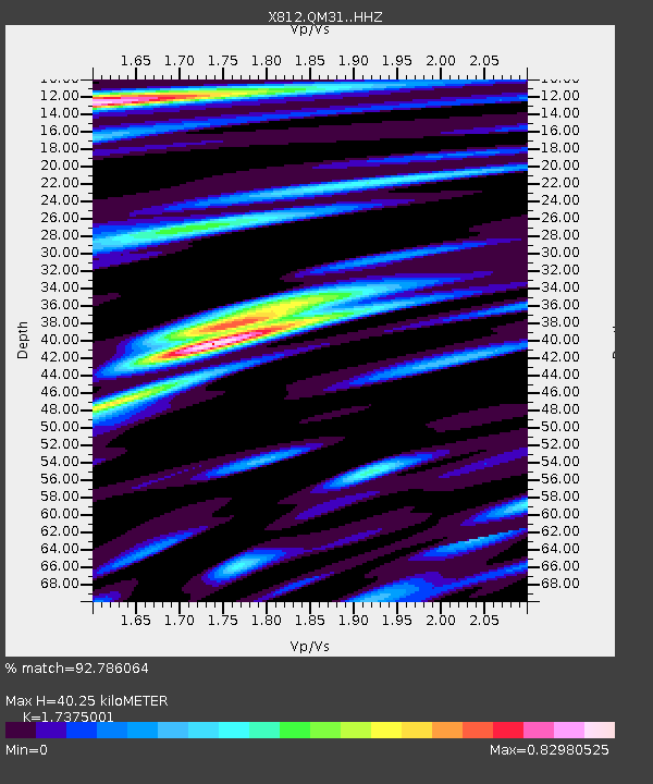
| Estimated Moho Depth: |
40.25 km |
| Estimated Crust Vp/Vs: |
1.74 |
| Assumed Crust Vp: |
6.419 km/s |
| Estimated Crust Vs: |
3.695 km/s |
| Estimated Crust Poisson's Ratio: |
0.25 |
|
| Radial Match: |
92.786064 % |
| Radial Bump: |
400 |
| Transverse Match: |
70.86272 % |
| Transverse Bump: |
400 |
| SOD ConfigId: |
7422571 |
| Insert Time: |
2019-04-19 02:46:11.047 +0000 |
| GWidth: |
2.5 |
| Max Bumps: |
400 |
| Tol: |
0.001 |
|

Signal To Noise
| Channel | StoN | STA | LTA |
| X8:QM31: :HHZ:20150529T07:08:36.729996Z | 19.427385 | 2.632262E-6 | 1.3549236E-7 |
| X8:QM31: :HHN:20150529T07:08:36.729996Z | 2.1016293 | 7.263985E-7 | 3.4563593E-7 |
| X8:QM31: :HHE:20150529T07:08:36.729996Z | 10.098826 | 6.6469596E-7 | 6.581913E-8 |
| Arrivals |
| Ps | 4.9 SECOND |
| PpPs | 16 SECOND |
| PsPs/PpSs | 21 SECOND |


