You are here: Home > Network List > X812 - Deep Structure of Three Continental Sutures in Eastern North America Stations List
> Station QM34 Ferme Vifranc, St-Pamphile, Quebec, Canada > Earthquake Result Viewer
QM34 Ferme Vifranc, St-Pamphile, Quebec, Canada - Earthquake Result Viewer
| Earthquake location: |
Alaska Peninsula |
| Earthquake latitude/longitude: |
56.7/-156.5 |
| Earthquake time(UTC): |
2015/05/29 (149) 07:00:08 GMT |
| Earthquake Depth: |
62 km |
| Earthquake Magnitude: |
6.8 MWP, 6.8 MI |
| Earthquake Catalog/Contributor: |
NEIC PDE/NEIC COMCAT |
|
| Network: |
X8 Deep Structure of Three Continental Sutures in Eastern North America |
| Station: |
QM34 Ferme Vifranc, St-Pamphile, Quebec, Canada |
| Lat/Lon: |
47.02 N/69.83 W |
| Elevation: |
374 m |
|
| Distance: |
50.9 deg |
| Az: |
61.589 deg |
| Baz: |
314.828 deg |
| Ray Param: |
0.067555934 |
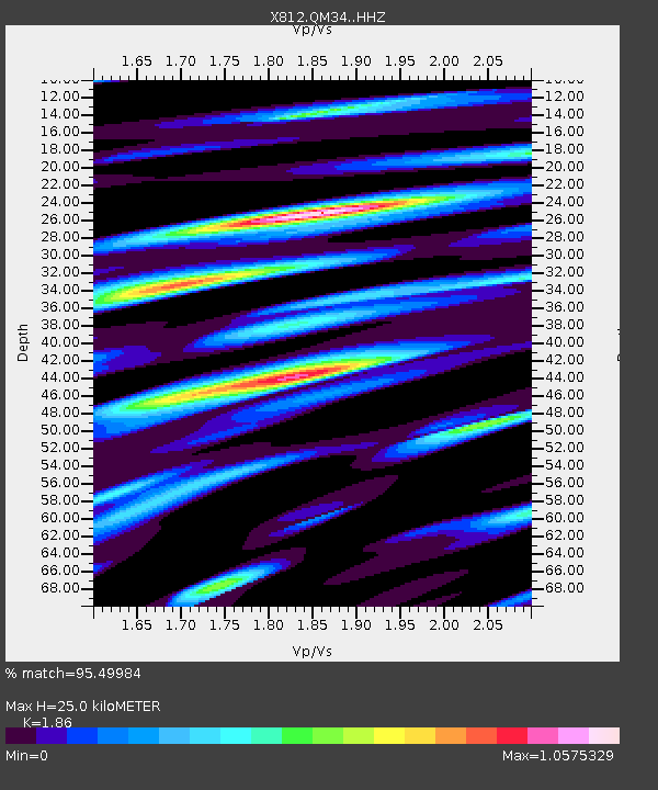
| Estimated Moho Depth: |
25.0 km |
| Estimated Crust Vp/Vs: |
1.86 |
| Assumed Crust Vp: |
6.419 km/s |
| Estimated Crust Vs: |
3.451 km/s |
| Estimated Crust Poisson's Ratio: |
0.30 |
|
| Radial Match: |
95.49984 % |
| Radial Bump: |
400 |
| Transverse Match: |
85.07535 % |
| Transverse Bump: |
400 |
| SOD ConfigId: |
7422571 |
| Insert Time: |
2019-04-19 02:46:11.196 +0000 |
| GWidth: |
2.5 |
| Max Bumps: |
400 |
| Tol: |
0.001 |
|
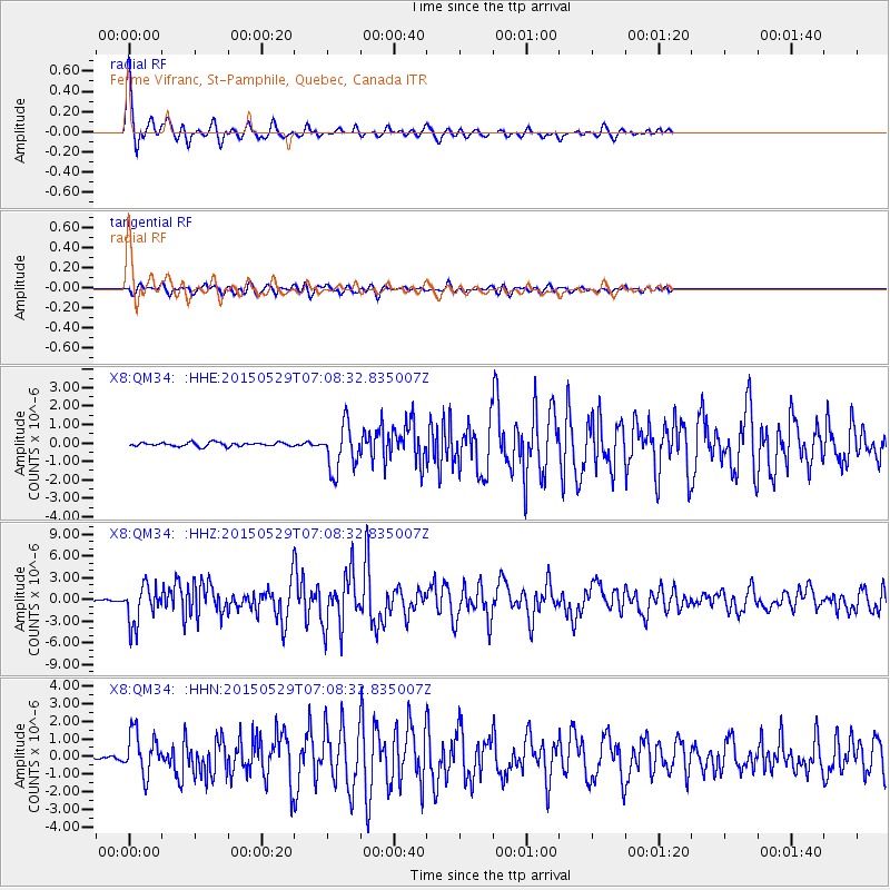
Signal To Noise
| Channel | StoN | STA | LTA |
| X8:QM34: :HHZ:20150529T07:08:32.835007Z | 21.359589 | 2.680983E-6 | 1.2551659E-7 |
| X8:QM34: :HHN:20150529T07:08:32.835007Z | 11.230757 | 1.197292E-6 | 1.0660831E-7 |
| X8:QM34: :HHE:20150529T07:08:32.835007Z | 12.323137 | 1.2564545E-6 | 1.0195898E-7 |
| Arrivals |
| Ps | 3.5 SECOND |
| PpPs | 11 SECOND |
| PsPs/PpSs | 14 SECOND |


