You are here: Home > Network List > X812 - Deep Structure of Three Continental Sutures in Eastern North America Stations List
> Station QM66 Explorers Mine, Chibougamau, Quebec, Canada > Earthquake Result Viewer
QM66 Explorers Mine, Chibougamau, Quebec, Canada - Earthquake Result Viewer
| Earthquake location: |
Alaska Peninsula |
| Earthquake latitude/longitude: |
56.7/-156.5 |
| Earthquake time(UTC): |
2015/05/29 (149) 07:00:08 GMT |
| Earthquake Depth: |
62 km |
| Earthquake Magnitude: |
6.8 MWP, 6.8 MI |
| Earthquake Catalog/Contributor: |
NEIC PDE/NEIC COMCAT |
|
| Network: |
X8 Deep Structure of Three Continental Sutures in Eastern North America |
| Station: |
QM66 Explorers Mine, Chibougamau, Quebec, Canada |
| Lat/Lon: |
49.49 N/74.44 W |
| Elevation: |
405 m |
|
| Distance: |
47.0 deg |
| Az: |
62.002 deg |
| Baz: |
311.671 deg |
| Ray Param: |
0.07008635 |
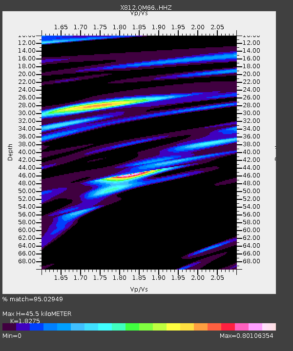
| Estimated Moho Depth: |
45.5 km |
| Estimated Crust Vp/Vs: |
1.83 |
| Assumed Crust Vp: |
6.61 km/s |
| Estimated Crust Vs: |
3.617 km/s |
| Estimated Crust Poisson's Ratio: |
0.29 |
|
| Radial Match: |
95.02949 % |
| Radial Bump: |
400 |
| Transverse Match: |
60.80433 % |
| Transverse Bump: |
400 |
| SOD ConfigId: |
7422571 |
| Insert Time: |
2019-04-19 02:46:17.642 +0000 |
| GWidth: |
2.5 |
| Max Bumps: |
400 |
| Tol: |
0.001 |
|

Signal To Noise
| Channel | StoN | STA | LTA |
| X8:QM66: :HHZ:20150529T07:08:02.844987Z | 27.604118 | 2.6278221E-6 | 9.519674E-8 |
| X8:QM66: :HHN:20150529T07:08:02.844987Z | 1.7170467 | 2.5189365E-6 | 1.4670169E-6 |
| X8:QM66: :HHE:20150529T07:08:02.844987Z | 2.6500368 | 2.5677577E-6 | 9.689518E-7 |
| Arrivals |
| Ps | 6.1 SECOND |
| PpPs | 18 SECOND |
| PsPs/PpSs | 24 SECOND |


