You are here: Home > Network List > IU - Global Seismograph Network (GSN - IRIS/USGS) Stations List
> Station XMAS Kiritimati Island, Republic of Kiribati > Earthquake Result Viewer
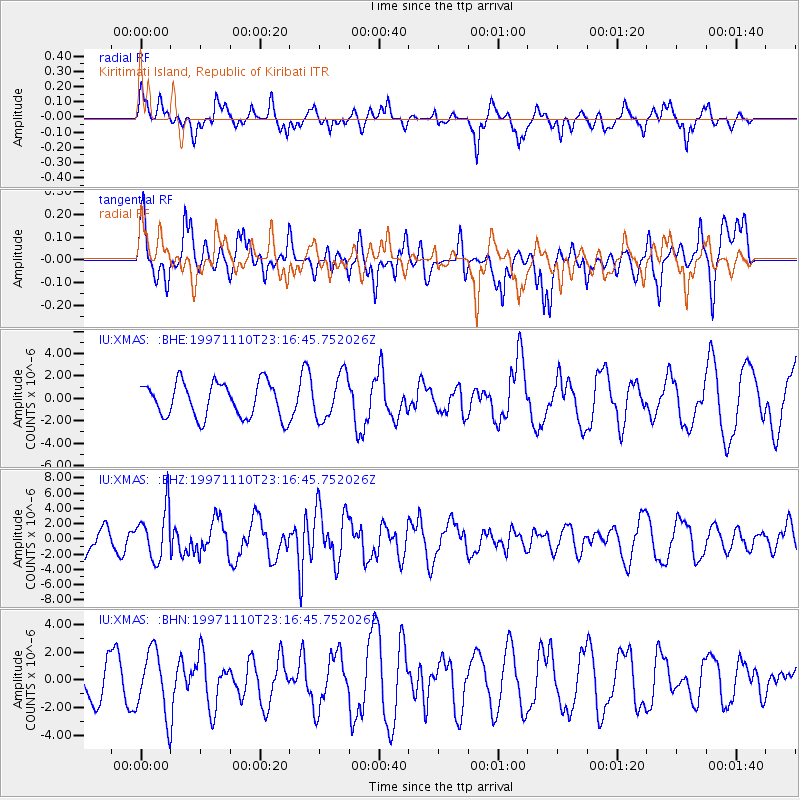
XMAS Kiritimati Island, Republic of Kiribati - Earthquake Result Viewer
*The percent match for this event was below the threshold and hence no stack was calculated.
| Earthquake location: |
Southeast Of Honshu, Japan |
| Earthquake latitude/longitude: |
31.2/140.5 |
| Earthquake time(UTC): |
1997/11/10 (314) 23:06:44 GMT |
| Earthquake Depth: |
86 km |
| Earthquake Magnitude: |
5.8 MB, 6.1 UNKNOWN, 6.1 MW |
| Earthquake Catalog/Contributor: |
WHDF/NEIC |
|
| Network: |
IU Global Seismograph Network (GSN - IRIS/USGS) |
| Station: |
XMAS Kiritimati Island, Republic of Kiribati |
| Lat/Lon: |
2.04 N/157.45 W |
| Elevation: |
2.0 m |
|
| Distance: |
65.2 deg |
| Az: |
103.43 deg |
| Baz: |
303.477 deg |
| Ray Param: |
$rayparam |
*The percent match for this event was below the threshold and hence was not used in the summary stack. |
|
| Radial Match: |
51.98949 % |
| Radial Bump: |
400 |
| Transverse Match: |
62.745247 % |
| Transverse Bump: |
400 |
| SOD ConfigId: |
4480 |
| Insert Time: |
2010-03-02 15:51:08.065 +0000 |
| GWidth: |
2.5 |
| Max Bumps: |
400 |
| Tol: |
0.001 |
|
Signal To Noise
| Channel | StoN | STA | LTA |
| IU:XMAS: :BHZ:19971110T23:16:45.752026Z | 1.8945365 | 3.2943135E-6 | 1.7388494E-6 |
| IU:XMAS: :BHN:19971110T23:16:45.752026Z | 1.8068247 | 2.3226933E-6 | 1.2855112E-6 |
| IU:XMAS: :BHE:19971110T23:16:45.752026Z | 1.280623 | 1.9740771E-6 | 1.5414975E-6 |
| Arrivals |
| Ps | |
| PpPs | |
| PsPs/PpSs | |


