You are here: Home > Network List > XL12 - Hangay Dome, Mongolia Stations List
> Station HV17 HV17 > Earthquake Result Viewer
HV17 HV17 - Earthquake Result Viewer
| Earthquake location: |
Alaska Peninsula |
| Earthquake latitude/longitude: |
56.7/-156.5 |
| Earthquake time(UTC): |
2015/05/29 (149) 07:00:08 GMT |
| Earthquake Depth: |
62 km |
| Earthquake Magnitude: |
6.8 MWP, 6.8 MI |
| Earthquake Catalog/Contributor: |
NEIC PDE/NEIC COMCAT |
|
| Network: |
XL Hangay Dome, Mongolia |
| Station: |
HV17 HV17 |
| Lat/Lon: |
50.54 N/100.40 E |
| Elevation: |
1692 m |
|
| Distance: |
55.8 deg |
| Az: |
311.249 deg |
| Baz: |
40.54 deg |
| Ray Param: |
0.06441629 |
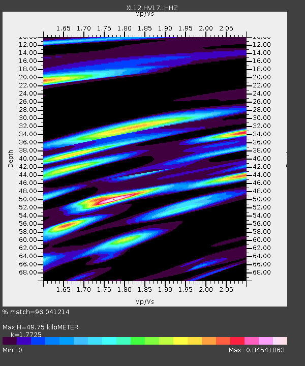
| Estimated Moho Depth: |
49.75 km |
| Estimated Crust Vp/Vs: |
1.77 |
| Assumed Crust Vp: |
6.419 km/s |
| Estimated Crust Vs: |
3.622 km/s |
| Estimated Crust Poisson's Ratio: |
0.27 |
|
| Radial Match: |
96.041214 % |
| Radial Bump: |
368 |
| Transverse Match: |
89.44953 % |
| Transverse Bump: |
400 |
| SOD ConfigId: |
7422571 |
| Insert Time: |
2019-04-19 02:46:43.191 +0000 |
| GWidth: |
2.5 |
| Max Bumps: |
400 |
| Tol: |
0.001 |
|

Signal To Noise
| Channel | StoN | STA | LTA |
| XL:HV17: :HHZ:20150529T07:09:07.129014Z | 89.49328 | 5.2701785E-6 | 5.88891E-8 |
| XL:HV17: :HHN:20150529T07:09:07.129014Z | 31.92623 | 2.0085515E-6 | 6.2912264E-8 |
| XL:HV17: :HHE:20150529T07:09:07.129014Z | 21.412169 | 1.8788592E-6 | 8.774726E-8 |
| Arrivals |
| Ps | 6.3 SECOND |
| PpPs | 20 SECOND |
| PsPs/PpSs | 27 SECOND |


