You are here: Home > Network List > XO11 - Ozark Illinois, Indiana and Kentucky ES Flexible Array Stations List
> Station KK48 KK48 of OIINK Flexarray > Earthquake Result Viewer
KK48 KK48 of OIINK Flexarray - Earthquake Result Viewer
| Earthquake location: |
Alaska Peninsula |
| Earthquake latitude/longitude: |
56.7/-156.5 |
| Earthquake time(UTC): |
2015/05/29 (149) 07:00:08 GMT |
| Earthquake Depth: |
62 km |
| Earthquake Magnitude: |
6.8 MWP, 6.8 MI |
| Earthquake Catalog/Contributor: |
NEIC PDE/NEIC COMCAT |
|
| Network: |
XO Ozark Illinois, Indiana and Kentucky ES Flexible Array |
| Station: |
KK48 KK48 of OIINK Flexarray |
| Lat/Lon: |
36.87 N/84.94 W |
| Elevation: |
318 m |
|
| Distance: |
50.4 deg |
| Az: |
81.164 deg |
| Baz: |
317.175 deg |
| Ray Param: |
0.06793294 |
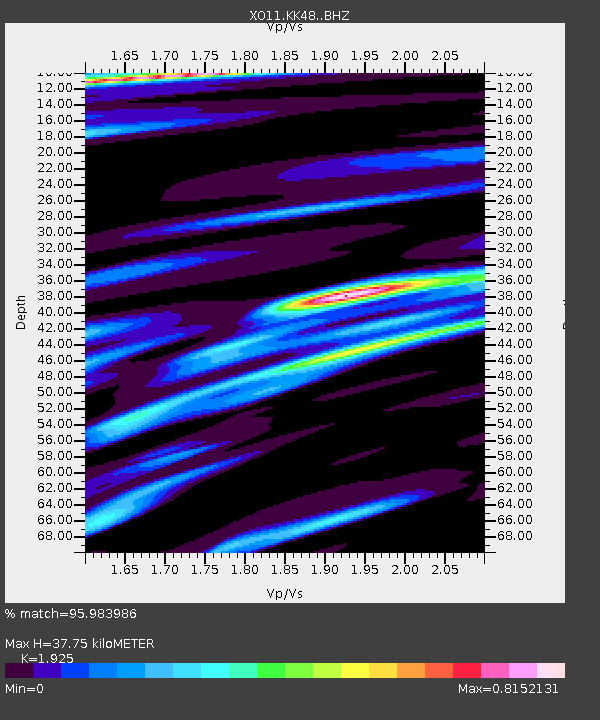
| Estimated Moho Depth: |
37.75 km |
| Estimated Crust Vp/Vs: |
1.92 |
| Assumed Crust Vp: |
6.476 km/s |
| Estimated Crust Vs: |
3.364 km/s |
| Estimated Crust Poisson's Ratio: |
0.32 |
|
| Radial Match: |
95.983986 % |
| Radial Bump: |
400 |
| Transverse Match: |
85.1173 % |
| Transverse Bump: |
400 |
| SOD ConfigId: |
7422571 |
| Insert Time: |
2019-04-19 02:47:06.421 +0000 |
| GWidth: |
2.5 |
| Max Bumps: |
400 |
| Tol: |
0.001 |
|

Signal To Noise
| Channel | StoN | STA | LTA |
| XO:KK48: :BHZ:20150529T07:08:28.515Z | 48.92368 | 4.022411E-6 | 8.221808E-8 |
| XO:KK48: :BHN:20150529T07:08:28.515Z | 26.04835 | 1.5777555E-6 | 6.0570265E-8 |
| XO:KK48: :BHE:20150529T07:08:28.515Z | 28.175394 | 1.3944333E-6 | 4.9491174E-8 |
| Arrivals |
| Ps | 5.7 SECOND |
| PpPs | 16 SECOND |
| PsPs/PpSs | 22 SECOND |


