You are here: Home > Network List > YC13 - Texas Brine Corporation Louisiana Seismic Network Stations List
> Station LA14 TBC Well 9, Belle Rose, Louisiana > Earthquake Result Viewer
LA14 TBC Well 9, Belle Rose, Louisiana - Earthquake Result Viewer
| Earthquake location: |
Alaska Peninsula |
| Earthquake latitude/longitude: |
56.7/-156.5 |
| Earthquake time(UTC): |
2015/05/29 (149) 07:00:08 GMT |
| Earthquake Depth: |
62 km |
| Earthquake Magnitude: |
6.8 MWP, 6.8 MI |
| Earthquake Catalog/Contributor: |
NEIC PDE/NEIC COMCAT |
|
| Network: |
YC Texas Brine Corporation Louisiana Seismic Network |
| Station: |
LA14 TBC Well 9, Belle Rose, Louisiana |
| Lat/Lon: |
30.01 N/91.14 W |
| Elevation: |
2.0 m |
|
| Distance: |
52.1 deg |
| Az: |
91.942 deg |
| Baz: |
320.531 deg |
| Ray Param: |
0.066811055 |
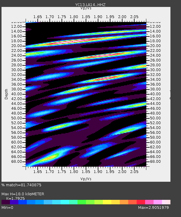
| Estimated Moho Depth: |
18.0 km |
| Estimated Crust Vp/Vs: |
1.79 |
| Assumed Crust Vp: |
6.065 km/s |
| Estimated Crust Vs: |
3.383 km/s |
| Estimated Crust Poisson's Ratio: |
0.27 |
|
| Radial Match: |
81.740875 % |
| Radial Bump: |
400 |
| Transverse Match: |
74.28135 % |
| Transverse Bump: |
400 |
| SOD ConfigId: |
7422571 |
| Insert Time: |
2019-04-19 02:47:16.007 +0000 |
| GWidth: |
2.5 |
| Max Bumps: |
400 |
| Tol: |
0.001 |
|

Signal To Noise
| Channel | StoN | STA | LTA |
| YC:LA14: :HHZ:20150529T07:08:41.520005Z | 36.08653 | 4.3611767E-6 | 1.2085331E-7 |
| YC:LA14: :HH1:20150529T07:08:41.520005Z | 3.2534266 | 8.243902E-7 | 2.5339136E-7 |
| YC:LA14: :HH2:20150529T07:08:41.520005Z | 9.952018 | 1.897303E-6 | 1.9064505E-7 |
| Arrivals |
| Ps | 2.5 SECOND |
| PpPs | 7.9 SECOND |
| PsPs/PpSs | 10 SECOND |


