You are here: Home > Network List > YN10 - San Jacinto Fault Zone Stations List
> Station JF00 JF00 > Earthquake Result Viewer
JF00 JF00 - Earthquake Result Viewer
| Earthquake location: |
Alaska Peninsula |
| Earthquake latitude/longitude: |
56.7/-156.5 |
| Earthquake time(UTC): |
2015/05/29 (149) 07:00:08 GMT |
| Earthquake Depth: |
62 km |
| Earthquake Magnitude: |
6.8 MWP, 6.8 MI |
| Earthquake Catalog/Contributor: |
NEIC PDE/NEIC COMCAT |
|
| Network: |
YN San Jacinto Fault Zone |
| Station: |
JF00 JF00 |
| Lat/Lon: |
33.42 N/116.40 W |
| Elevation: |
646 m |
|
| Distance: |
35.9 deg |
| Az: |
113.188 deg |
| Baz: |
322.672 deg |
| Ray Param: |
0.076801755 |
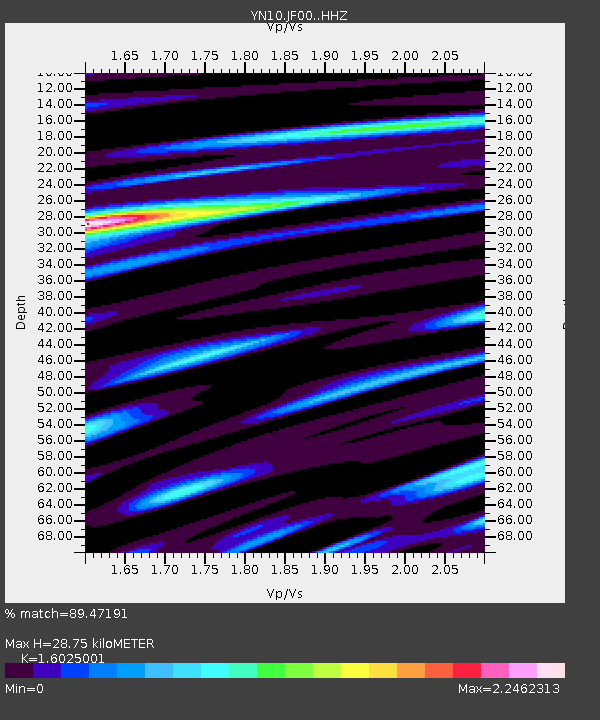
| Estimated Moho Depth: |
28.75 km |
| Estimated Crust Vp/Vs: |
1.60 |
| Assumed Crust Vp: |
6.264 km/s |
| Estimated Crust Vs: |
3.909 km/s |
| Estimated Crust Poisson's Ratio: |
0.18 |
|
| Radial Match: |
89.47191 % |
| Radial Bump: |
400 |
| Transverse Match: |
74.36849 % |
| Transverse Bump: |
400 |
| SOD ConfigId: |
7422571 |
| Insert Time: |
2019-04-19 02:47:22.148 +0000 |
| GWidth: |
2.5 |
| Max Bumps: |
400 |
| Tol: |
0.001 |
|

Signal To Noise
| Channel | StoN | STA | LTA |
| YN:JF00: :HHZ:20150529T07:06:32.258988Z | 32.531002 | 6.3944804E-6 | 1.9656574E-7 |
| YN:JF00: :HHN:20150529T07:06:32.258988Z | 12.119923 | 3.709236E-6 | 3.060445E-7 |
| YN:JF00: :HHE:20150529T07:06:32.258988Z | 10.086099 | 2.2906593E-6 | 2.2711053E-7 |
| Arrivals |
| Ps | 3.0 SECOND |
| PpPs | 11 SECOND |
| PsPs/PpSs | 14 SECOND |


