You are here: Home > Network List > YN10 - San Jacinto Fault Zone Stations List
> Station JFS4 JFS4 > Earthquake Result Viewer
JFS4 JFS4 - Earthquake Result Viewer
| Earthquake location: |
Alaska Peninsula |
| Earthquake latitude/longitude: |
56.7/-156.5 |
| Earthquake time(UTC): |
2015/05/29 (149) 07:00:08 GMT |
| Earthquake Depth: |
62 km |
| Earthquake Magnitude: |
6.8 MWP, 6.8 MI |
| Earthquake Catalog/Contributor: |
NEIC PDE/NEIC COMCAT |
|
| Network: |
YN San Jacinto Fault Zone |
| Station: |
JFS4 JFS4 |
| Lat/Lon: |
33.42 N/116.40 W |
| Elevation: |
645 m |
|
| Distance: |
35.9 deg |
| Az: |
113.19 deg |
| Baz: |
322.673 deg |
| Ray Param: |
0.07680217 |
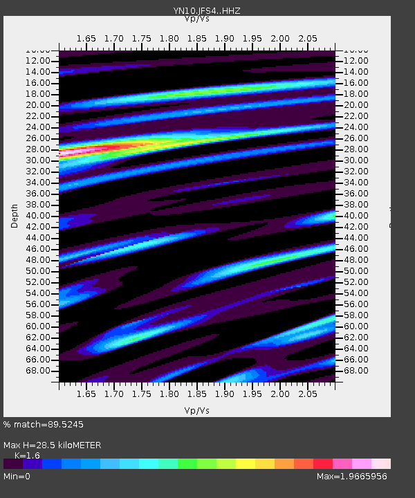
| Estimated Moho Depth: |
28.5 km |
| Estimated Crust Vp/Vs: |
1.60 |
| Assumed Crust Vp: |
6.264 km/s |
| Estimated Crust Vs: |
3.915 km/s |
| Estimated Crust Poisson's Ratio: |
0.18 |
|
| Radial Match: |
89.5245 % |
| Radial Bump: |
400 |
| Transverse Match: |
71.61526 % |
| Transverse Bump: |
400 |
| SOD ConfigId: |
7422571 |
| Insert Time: |
2019-04-19 02:47:26.784 +0000 |
| GWidth: |
2.5 |
| Max Bumps: |
400 |
| Tol: |
0.001 |
|

Signal To Noise
| Channel | StoN | STA | LTA |
| YN:JFS4: :HHZ:20150529T07:06:32.258988Z | 29.441109 | 6.3525604E-6 | 2.1577178E-7 |
| YN:JFS4: :HHN:20150529T07:06:32.258988Z | 11.885153 | 3.616307E-6 | 3.0427097E-7 |
| YN:JFS4: :HHE:20150529T07:06:32.258988Z | 9.435952 | 2.175674E-6 | 2.305728E-7 |
| Arrivals |
| Ps | 3.0 SECOND |
| PpPs | 11 SECOND |
| PsPs/PpSs | 14 SECOND |


