You are here: Home > Network List > YN10 - San Jacinto Fault Zone Stations List
> Station TR03 TR03 > Earthquake Result Viewer
TR03 TR03 - Earthquake Result Viewer
| Earthquake location: |
Alaska Peninsula |
| Earthquake latitude/longitude: |
56.7/-156.5 |
| Earthquake time(UTC): |
2015/05/29 (149) 07:00:08 GMT |
| Earthquake Depth: |
62 km |
| Earthquake Magnitude: |
6.8 MWP, 6.8 MI |
| Earthquake Catalog/Contributor: |
NEIC PDE/NEIC COMCAT |
|
| Network: |
YN San Jacinto Fault Zone |
| Station: |
TR03 TR03 |
| Lat/Lon: |
33.41 N/116.42 W |
| Elevation: |
739 m |
|
| Distance: |
35.9 deg |
| Az: |
113.226 deg |
| Baz: |
322.692 deg |
| Ray Param: |
0.07680159 |
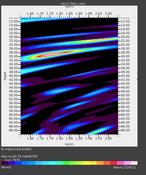
| Estimated Moho Depth: |
28.75 km |
| Estimated Crust Vp/Vs: |
1.76 |
| Assumed Crust Vp: |
6.264 km/s |
| Estimated Crust Vs: |
3.564 km/s |
| Estimated Crust Poisson's Ratio: |
0.26 |
|
| Radial Match: |
84.62658 % |
| Radial Bump: |
400 |
| Transverse Match: |
82.84346 % |
| Transverse Bump: |
400 |
| SOD ConfigId: |
7422571 |
| Insert Time: |
2019-04-19 02:47:30.050 +0000 |
| GWidth: |
2.5 |
| Max Bumps: |
400 |
| Tol: |
0.001 |
|

Signal To Noise
| Channel | StoN | STA | LTA |
| YN:TR03: :HHZ:20150529T07:06:32.258988Z | 26.447388 | 6.244158E-6 | 2.3609736E-7 |
| YN:TR03: :HHN:20150529T07:06:32.258988Z | 8.761537 | 2.3416771E-6 | 2.6726784E-7 |
| YN:TR03: :HHE:20150529T07:06:32.258988Z | 11.096992 | 3.0511499E-6 | 2.749529E-7 |
| Arrivals |
| Ps | 3.7 SECOND |
| PpPs | 12 SECOND |
| PsPs/PpSs | 16 SECOND |


