You are here: Home > Network List > YN10 - San Jacinto Fault Zone Stations List
> Station TR04 TR04 > Earthquake Result Viewer
TR04 TR04 - Earthquake Result Viewer
| Earthquake location: |
Alaska Peninsula |
| Earthquake latitude/longitude: |
56.7/-156.5 |
| Earthquake time(UTC): |
2015/05/29 (149) 07:00:08 GMT |
| Earthquake Depth: |
62 km |
| Earthquake Magnitude: |
6.8 MWP, 6.8 MI |
| Earthquake Catalog/Contributor: |
NEIC PDE/NEIC COMCAT |
|
| Network: |
YN San Jacinto Fault Zone |
| Station: |
TR04 TR04 |
| Lat/Lon: |
33.40 N/116.43 W |
| Elevation: |
774 m |
|
| Distance: |
35.9 deg |
| Az: |
113.24 deg |
| Baz: |
322.702 deg |
| Ray Param: |
0.07679773 |
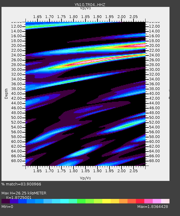
| Estimated Moho Depth: |
26.25 km |
| Estimated Crust Vp/Vs: |
1.87 |
| Assumed Crust Vp: |
6.264 km/s |
| Estimated Crust Vs: |
3.345 km/s |
| Estimated Crust Poisson's Ratio: |
0.30 |
|
| Radial Match: |
83.908966 % |
| Radial Bump: |
400 |
| Transverse Match: |
83.776505 % |
| Transverse Bump: |
400 |
| SOD ConfigId: |
7422571 |
| Insert Time: |
2019-04-19 02:47:30.075 +0000 |
| GWidth: |
2.5 |
| Max Bumps: |
400 |
| Tol: |
0.001 |
|

Signal To Noise
| Channel | StoN | STA | LTA |
| YN:TR04: :HHZ:20150529T07:06:32.32399Z | 30.82558 | 7.2768435E-6 | 2.3606509E-7 |
| YN:TR04: :HHN:20150529T07:06:32.32399Z | 8.298845 | 2.5353686E-6 | 3.055086E-7 |
| YN:TR04: :HHE:20150529T07:06:32.32399Z | 13.866908 | 3.423488E-6 | 2.4688185E-7 |
| Arrivals |
| Ps | 3.9 SECOND |
| PpPs | 11 SECOND |
| PsPs/PpSs | 15 SECOND |


