You are here: Home > Network List > IU - Global Seismograph Network (GSN - IRIS/USGS) Stations List
> Station KNTN Kanton, Kiritibati > Earthquake Result Viewer
KNTN Kanton, Kiritibati - Earthquake Result Viewer

| Earthquake location: |
Eastern Honshu, Japan |
| Earthquake latitude/longitude: |
39.8/141.5 |
| Earthquake time(UTC): |
2008/07/23 (205) 15:26:19 GMT |
| Earthquake Depth: |
108 km |
| Earthquake Magnitude: |
6.6 MB, 6.8 MW, 6.8 MW |
| Earthquake Catalog/Contributor: |
WHDF/NEIC |
|
| Network: |
IU Global Seismograph Network (GSN - IRIS/USGS) |
| Station: |
KNTN Kanton, Kiritibati |
| Lat/Lon: |
2.77 S/171.72 W |
| Elevation: |
20 m |
|
| Distance: |
60.3 deg |
| Az: |
122.993 deg |
| Baz: |
319.693 deg |
| Ray Param: |
0.061329108 |
| Estimated Moho Depth: |
62.5 km |
| Estimated Crust Vp/Vs: |
1.94 |
| Assumed Crust Vp: |
4.24 km/s |
| Estimated Crust Vs: |
2.188 km/s |
| Estimated Crust Poisson's Ratio: |
0.32 |
|
| Radial Match: |
92.2356 % |
| Radial Bump: |
342 |
| Transverse Match: |
65.68851 % |
| Transverse Bump: |
400 |
| SOD ConfigId: |
2504 |
| Insert Time: |
2010-03-02 15:51:22.326 +0000 |
| GWidth: |
2.5 |
| Max Bumps: |
400 |
| Tol: |
0.001 |
|
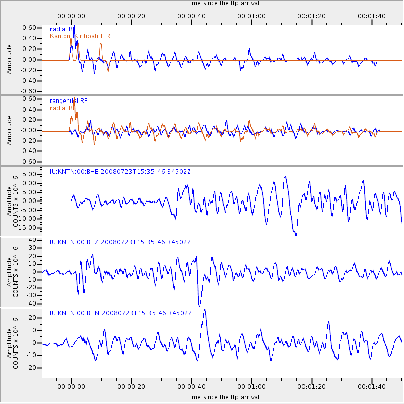
Signal To Noise
| Channel | StoN | STA | LTA |
| IU:KNTN:00:BHZ:20080723T15:35:46.34502Z | 7.9749804 | 1.20490195E-5 | 1.5108526E-6 |
| IU:KNTN:00:BHN:20080723T15:35:46.34502Z | 2.0237198 | 3.351908E-6 | 1.6563104E-6 |
| IU:KNTN:00:BHE:20080723T15:35:46.34502Z | 2.6977913 | 4.415282E-6 | 1.6366284E-6 |
| Arrivals |
| Ps | 14 SECOND |
| PpPs | 43 SECOND |
| PsPs/PpSs | 57 SECOND |


