You are here: Home > Network List > IU - Global Seismograph Network (GSN - IRIS/USGS) Stations List
> Station KNTN Kanton, Kiritibati > Earthquake Result Viewer
KNTN Kanton, Kiritibati - Earthquake Result Viewer

| Earthquake location: |
Sea Of Okhotsk |
| Earthquake latitude/longitude: |
54.2/154.3 |
| Earthquake time(UTC): |
2008/11/24 (329) 09:02:58 GMT |
| Earthquake Depth: |
492 km |
| Earthquake Magnitude: |
6.5 MB, 7.3 MW, 7.3 MW |
| Earthquake Catalog/Contributor: |
WHDF/NEIC |
|
| Network: |
IU Global Seismograph Network (GSN - IRIS/USGS) |
| Station: |
KNTN Kanton, Kiritibati |
| Lat/Lon: |
2.77 S/171.72 W |
| Elevation: |
20 m |
|
| Distance: |
63.4 deg |
| Az: |
141.389 deg |
| Baz: |
338.467 deg |
| Ray Param: |
0.057827298 |
| Estimated Moho Depth: |
10.25 km |
| Estimated Crust Vp/Vs: |
1.71 |
| Assumed Crust Vp: |
4.24 km/s |
| Estimated Crust Vs: |
2.479 km/s |
| Estimated Crust Poisson's Ratio: |
0.24 |
|
| Radial Match: |
83.74683 % |
| Radial Bump: |
292 |
| Transverse Match: |
72.34289 % |
| Transverse Bump: |
400 |
| SOD ConfigId: |
2658 |
| Insert Time: |
2010-03-02 15:51:27.086 +0000 |
| GWidth: |
2.5 |
| Max Bumps: |
400 |
| Tol: |
0.001 |
|
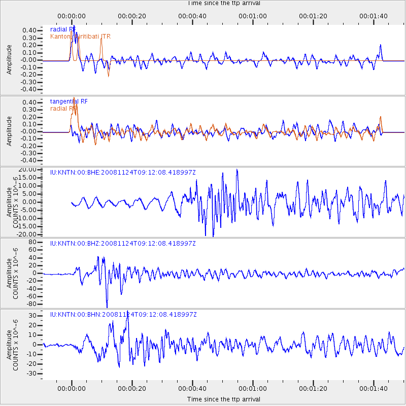
Signal To Noise
| Channel | StoN | STA | LTA |
| IU:KNTN:00:BHZ:20081124T09:12:08.418997Z | 12.521254 | 1.1548747E-5 | 9.2233154E-7 |
| IU:KNTN:00:BHN:20081124T09:12:08.418997Z | 2.4037542 | 4.1814737E-6 | 1.7395596E-6 |
| IU:KNTN:00:BHE:20081124T09:12:08.418997Z | 2.0000336 | 3.6416243E-6 | 1.8207814E-6 |
| Arrivals |
| Ps | 1.7 SECOND |
| PpPs | 6.4 SECOND |
| PsPs/PpSs | 8.2 SECOND |


