You are here: Home > Network List > IU - Global Seismograph Network (GSN - IRIS/USGS) Stations List
> Station KNTN Kanton, Kiritibati > Earthquake Result Viewer
KNTN Kanton, Kiritibati - Earthquake Result Viewer
| Earthquake location: |
Southeast Of Honshu, Japan |
| Earthquake latitude/longitude: |
32.8/140.4 |
| Earthquake time(UTC): |
2009/08/12 (224) 22:48:51 GMT |
| Earthquake Depth: |
53 km |
| Earthquake Magnitude: |
6.2 MB, 6.6 MW, 6.6 MW |
| Earthquake Catalog/Contributor: |
WHDF/NEIC |
|
| Network: |
IU Global Seismograph Network (GSN - IRIS/USGS) |
| Station: |
KNTN Kanton, Kiritibati |
| Lat/Lon: |
2.77 S/171.72 W |
| Elevation: |
20 m |
|
| Distance: |
57.4 deg |
| Az: |
118.471 deg |
| Baz: |
312.18 deg |
| Ray Param: |
0.06336061 |
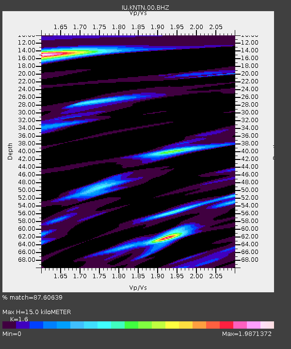
| Estimated Moho Depth: |
15.0 km |
| Estimated Crust Vp/Vs: |
1.60 |
| Assumed Crust Vp: |
4.24 km/s |
| Estimated Crust Vs: |
2.65 km/s |
| Estimated Crust Poisson's Ratio: |
0.18 |
|
| Radial Match: |
87.60639 % |
| Radial Bump: |
354 |
| Transverse Match: |
56.191437 % |
| Transverse Bump: |
396 |
| SOD ConfigId: |
2622 |
| Insert Time: |
2010-03-02 15:51:28.358 +0000 |
| GWidth: |
2.5 |
| Max Bumps: |
400 |
| Tol: |
0.001 |
|

Signal To Noise
| Channel | StoN | STA | LTA |
| IU:KNTN:00:BHZ:20090812T22:58:04.170Z | 9.165442 | 8.828931E-6 | 9.632847E-7 |
| IU:KNTN:00:BHN:20090812T22:58:04.170Z | 0.9967152 | 2.8833433E-6 | 2.8928457E-6 |
| IU:KNTN:00:BHE:20090812T22:58:04.170Z | 1.8392202 | 2.147355E-6 | 1.1675355E-6 |
| Arrivals |
| Ps | 2.2 SECOND |
| PpPs | 9.0 SECOND |
| PsPs/PpSs | 11 SECOND |


