You are here: Home > Network List > ZJ12 - Transantarctic Mountains Northern Network Stations List
> Station SHRD Lister Nunataks, Antarctica > Earthquake Result Viewer
SHRD Lister Nunataks, Antarctica - Earthquake Result Viewer
| Earthquake location: |
Southeast Indian Ridge |
| Earthquake latitude/longitude: |
-47.5/100.1 |
| Earthquake time(UTC): |
2015/05/29 (149) 08:40:13 GMT |
| Earthquake Depth: |
11 km |
| Earthquake Magnitude: |
5.9 MW, 5.1 mb, 5.7 MS |
| Earthquake Catalog/Contributor: |
ISC/ISC |
|
| Network: |
ZJ Transantarctic Mountains Northern Network |
| Station: |
SHRD Lister Nunataks, Antarctica |
| Lat/Lon: |
73.40 S/160.50 E |
| Elevation: |
2457 m |
|
| Distance: |
36.9 deg |
| Az: |
155.373 deg |
| Baz: |
280.506 deg |
| Ray Param: |
0.076443724 |
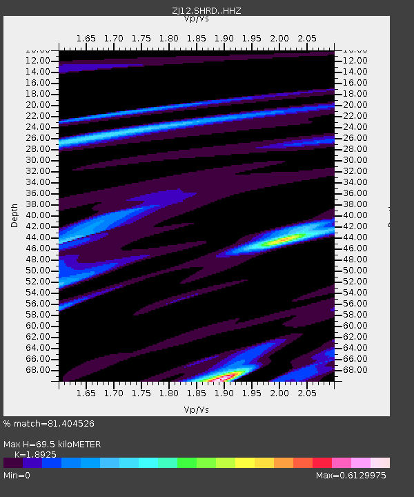
| Estimated Moho Depth: |
69.5 km |
| Estimated Crust Vp/Vs: |
1.89 |
| Assumed Crust Vp: |
6.264 km/s |
| Estimated Crust Vs: |
3.31 km/s |
| Estimated Crust Poisson's Ratio: |
0.31 |
|
| Radial Match: |
81.404526 % |
| Radial Bump: |
400 |
| Transverse Match: |
85.92506 % |
| Transverse Bump: |
327 |
| SOD ConfigId: |
7422571 |
| Insert Time: |
2019-04-19 02:49:51.783 +0000 |
| GWidth: |
2.5 |
| Max Bumps: |
400 |
| Tol: |
0.001 |
|

Signal To Noise
| Channel | StoN | STA | LTA |
| ZJ:SHRD: :HHZ:20150529T08:46:50.789003Z | 0.7213188 | 3.647958E-7 | 5.0573453E-7 |
| ZJ:SHRD: :HHN:20150529T08:46:50.789003Z | 2.9015822 | 7.782146E-7 | 2.6820354E-7 |
| ZJ:SHRD: :HHE:20150529T08:46:50.789003Z | 0.7868691 | 2.1617089E-7 | 2.7472282E-7 |
| Arrivals |
| Ps | 11 SECOND |
| PpPs | 30 SECOND |
| PsPs/PpSs | 41 SECOND |


