You are here: Home > Network List > IU - Global Seismograph Network (GSN - IRIS/USGS) Stations List
> Station KNTN Kanton, Kiritibati > Earthquake Result Viewer
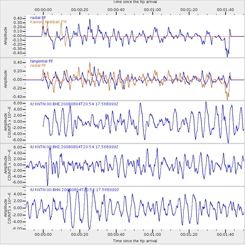
KNTN Kanton, Kiritibati - Earthquake Result Viewer
*The percent match for this event was below the threshold and hence no stack was calculated.
| Earthquake location: |
Banda Sea |
| Earthquake latitude/longitude: |
-5.9/130.2 |
| Earthquake time(UTC): |
2008/08/04 (217) 20:45:13 GMT |
| Earthquake Depth: |
174 km |
| Earthquake Magnitude: |
6.1 MB, 6.3 MW, 6.2 MW |
| Earthquake Catalog/Contributor: |
WHDF/NEIC |
|
| Network: |
IU Global Seismograph Network (GSN - IRIS/USGS) |
| Station: |
KNTN Kanton, Kiritibati |
| Lat/Lon: |
2.77 S/171.72 W |
| Elevation: |
20 m |
|
| Distance: |
58.0 deg |
| Az: |
89.579 deg |
| Baz: |
264.791 deg |
| Ray Param: |
$rayparam |
*The percent match for this event was below the threshold and hence was not used in the summary stack. |
|
| Radial Match: |
45.13066 % |
| Radial Bump: |
367 |
| Transverse Match: |
36.632805 % |
| Transverse Bump: |
285 |
| SOD ConfigId: |
2504 |
| Insert Time: |
2010-03-02 15:51:31.964 +0000 |
| GWidth: |
2.5 |
| Max Bumps: |
400 |
| Tol: |
0.001 |
|
Signal To Noise
| Channel | StoN | STA | LTA |
| IU:KNTN:00:BHZ:20080804T20:54:17.568999Z | 3.1661816 | 3.1978486E-6 | 1.0100017E-6 |
| IU:KNTN:00:BHN:20080804T20:54:17.568999Z | 0.94682336 | 1.4896772E-6 | 1.5733423E-6 |
| IU:KNTN:00:BHE:20080804T20:54:17.568999Z | 0.53383225 | 1.3202543E-6 | 2.4731632E-6 |
| Arrivals |
| Ps | |
| PpPs | |
| PsPs/PpSs | |


