You are here: Home > Network List > IU - Global Seismograph Network (GSN - IRIS/USGS) Stations List
> Station KNTN Kanton, Kiritibati > Earthquake Result Viewer
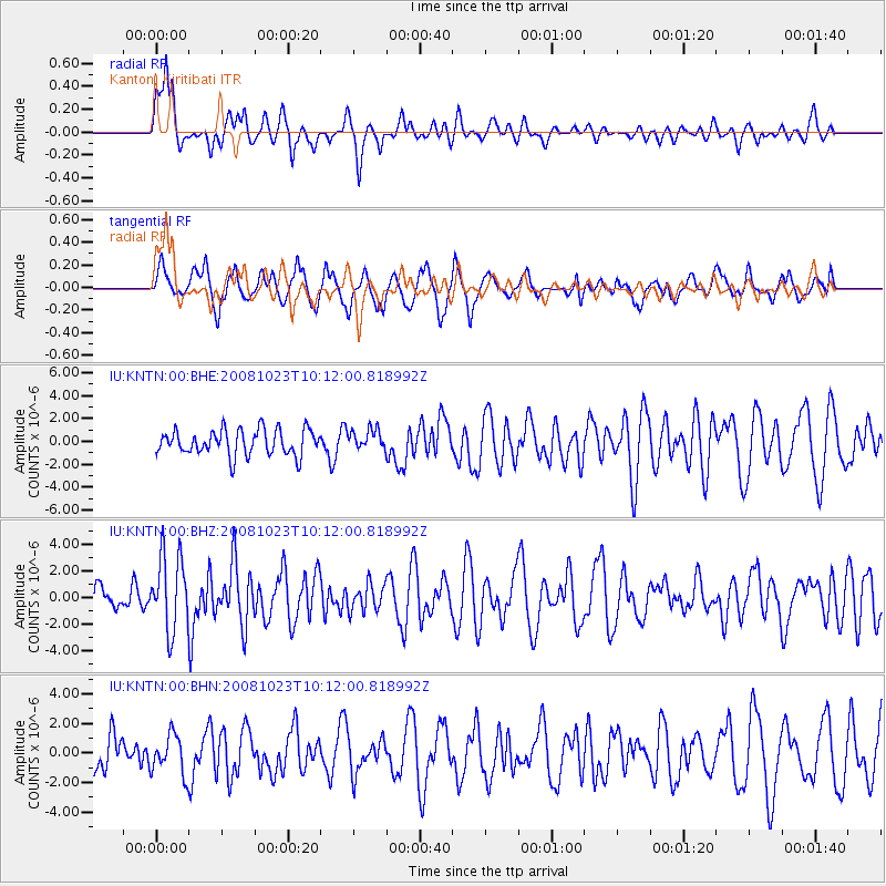
KNTN Kanton, Kiritibati - Earthquake Result Viewer
*The percent match for this event was below the threshold and hence no stack was calculated.
| Earthquake location: |
Admiralty Islands Region, P.N.G. |
| Earthquake latitude/longitude: |
-2.6/145.6 |
| Earthquake time(UTC): |
2008/10/23 (297) 10:04:35 GMT |
| Earthquake Depth: |
10 km |
| Earthquake Magnitude: |
6.0 MB, 6.3 MS, 6.3 MW, 6.3 MW |
| Earthquake Catalog/Contributor: |
WHDF/NEIC |
|
| Network: |
IU Global Seismograph Network (GSN - IRIS/USGS) |
| Station: |
KNTN Kanton, Kiritibati |
| Lat/Lon: |
2.77 S/171.72 W |
| Elevation: |
20 m |
|
| Distance: |
42.7 deg |
| Az: |
91.227 deg |
| Baz: |
269.127 deg |
| Ray Param: |
$rayparam |
*The percent match for this event was below the threshold and hence was not used in the summary stack. |
|
| Radial Match: |
73.56188 % |
| Radial Bump: |
400 |
| Transverse Match: |
73.65325 % |
| Transverse Bump: |
400 |
| SOD ConfigId: |
2556 |
| Insert Time: |
2010-03-02 15:51:35.958 +0000 |
| GWidth: |
2.5 |
| Max Bumps: |
400 |
| Tol: |
0.001 |
|
Signal To Noise
| Channel | StoN | STA | LTA |
| IU:KNTN:00:BHZ:20081023T10:12:00.818992Z | 3.806203 | 2.8132827E-6 | 7.3913105E-7 |
| IU:KNTN:00:BHN:20081023T10:12:00.818992Z | 1.0554471 | 1.3200389E-6 | 1.2506918E-6 |
| IU:KNTN:00:BHE:20081023T10:12:00.818992Z | 0.7875451 | 8.7992794E-7 | 1.1173048E-6 |
| Arrivals |
| Ps | |
| PpPs | |
| PsPs/PpSs | |


