You are here: Home > Network List > CI - Caltech Regional Seismic Network Stations List
> Station OSI Osito Adit, California, USA > Earthquake Result Viewer
OSI Osito Adit, California, USA - Earthquake Result Viewer
| Earthquake location: |
New Ireland Region, P.N.G. |
| Earthquake latitude/longitude: |
-4.5/153.5 |
| Earthquake time(UTC): |
2005/09/09 (252) 07:26:43 GMT |
| Earthquake Depth: |
90 km |
| Earthquake Magnitude: |
6.3 MB, 7.7 MW, 7.5 MW |
| Earthquake Catalog/Contributor: |
WHDF/NEIC |
|
| Network: |
CI Caltech Regional Seismic Network |
| Station: |
OSI Osito Adit, California, USA |
| Lat/Lon: |
34.61 N/118.72 W |
| Elevation: |
706 m |
|
| Distance: |
90.7 deg |
| Az: |
55.511 deg |
| Baz: |
265.04 deg |
| Ray Param: |
0.041634656 |
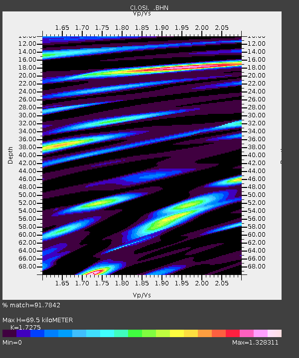
| Estimated Moho Depth: |
69.5 km |
| Estimated Crust Vp/Vs: |
1.73 |
| Assumed Crust Vp: |
6.1 km/s |
| Estimated Crust Vs: |
3.531 km/s |
| Estimated Crust Poisson's Ratio: |
0.25 |
|
| Radial Match: |
91.7842 % |
| Radial Bump: |
400 |
| Transverse Match: |
92.04454 % |
| Transverse Bump: |
400 |
| SOD ConfigId: |
2475 |
| Insert Time: |
2010-02-25 21:27:11.919 +0000 |
| GWidth: |
2.5 |
| Max Bumps: |
400 |
| Tol: |
0.001 |
|
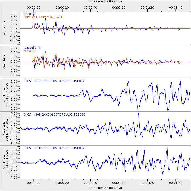
Signal To Noise
| Channel | StoN | STA | LTA |
| CI:OSI: :BHN:20050909T07:39:05.39803Z | 1.122098 | 1.4795339E-7 | 1.3185424E-7 |
| CI:OSI: :BHE:20050909T07:39:05.39803Z | 2.6367924 | 3.4770656E-7 | 1.3186725E-7 |
| CI:OSI: :BHZ:20050909T07:39:05.39803Z | 6.1377597 | 1.2607784E-6 | 2.0541346E-7 |
| Arrivals |
| Ps | 8.4 SECOND |
| PpPs | 30 SECOND |
| PsPs/PpSs | 39 SECOND |


